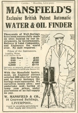
In Part 1 and Part 2, I looked at how early British ‘geophys’ technology and Mauritian treasure hunting dreams converged in the 1920s. But once the Liverpool firm of W. Mansfield & Co had been persuaded by the Klondyke Syndicate to jump into the Bernardin Nageon de l’Estang treasure-hunting fire, I think it’s safe to say that just about all outcomes were going to be bad.

So what did happen next? And who exactly was “Captain Russell”, Mansfield’s main man in Mauritius?

The Death of the Dream

From a short article in the The Daily News (4th February 1927, p.10), we can see almost exactly to the day when Mansfield’s expensive treasure-hunting collaboration with the Klondyke Syndicate ended up:

After several unsuccessful attempts to locate what is known as the “Klondyke Treasure” on this island, Captain Russell, of Liverpool, is returning to England.

It is understood that Captain Russell was sent out by a large Liverpool firm for the purpose of prospecting for precious metal. A staff of 50 men and women, under his control, have been engaged for the past 18 months in elaborate excavations. Each successive attempt has ended in failure, and the expedition has finally decided to abandon the treasure hunt.

The last attempt alone is said to have cost £15,000.

But who was he? For several years, I and others have been trying to find out more about Captain Russell: apart from a few brief newspaper articles (such as the Daily News article above), he seemed to have been almost as hard to find as the Klondyke Treasure itself.

Well, that was the situation until this weekend, when my latest attempt to rake keyword phrases through the British Newspaper Archives at long last yielded what seem to be interesting results…

The Lusitania!

In the Linlithgowshire Gazette of 17th May 1935 p.3 (don’t say I don’t spoil you), I found an article discussing a particularly hi-tech sea expedition to locate the wreck of the Lusitania:

An expedition will set out from the Clyde next month to the wreck of the Lusitana [sic] to attempt to retrieve documents and other valuables locked in her strongroom.

Cinema pictures and still photographs of the liner will be taken to show the world how the former pride of the Clyde lies shattered under the waves.

The venture is being organised by the Argonaut Corporation, Ltd., of London and Glasgow.

A ship named the Orphir is now being fitted out in the Beardmore Dockyard at Dalmuir.

The equipment embodies all the latest contributions of modern science and engineering to deep-sea exploration. One of the most valuable units is a flexible metal diving suit, fitted with mechanical hands, which will enable divers to work safely and comfortably in depths hitherto unattainable, with the mobility of the ordinary rubber dress.

Wonderfully, the (actually very fascinating) Coast Monkey website has some pictures of this state-of-the-art diving suit from 1935 being lowered into the water with intrepid diver Jim Jarrett inside, which you really need to see here to appreciate:

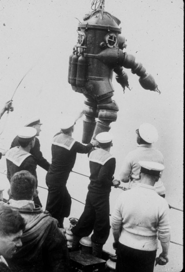
The metal dress was tested in Loch Ness by experts, who testified that at a depth of about 450 feet they had the same freedom of movement as was possible at only a few feet down.

With the new dress, divers will be able easily to reach the Lusitania, lying 280 feet deep, and work their way freely into the wreck, if necessary burning a passage through the steel hull with oxy-hydrogen burners.

Locating the Wreck

The article continues:

It is known that the Lusitania lies approximately ten miles off the Old Head of Kinsale, Ireland, and it will be necessary to scour about 15 square miles of the ocean bed to find her.

To eliminate the hit-or-miss element in the search, the organisers of the expedition will divide the area into squares, each of which will be explored in turn until the ship is located or the entire area covered.

A buoy will be anchored in the centre of the square, and measuring with a rangefinder the distance of the ship from the buoy, in conjunction with compass bearings, the invisible sea furrow ploughed by the ship will be accurately traced on a specially made chart. The chart will show the area covered each day, and make it impossible for the navigator to duplicate his tracks.

NOTHING FANTASTIC

Captain Henry Russell, marine superintendent of the expedition company, explained on Monday the method of operation in detail.

Captain Russell emphasised that there was nothing hare-brained or fantastic about the expedition. “I might emphasise that we are not going to make any attempt to refloat the Lusitania – a project which would be absurd,” he said.

“Nor do we expect to find any bullion on board. This is not a treasure-hunt. It is a practical demonstration of what can be done to explore the hitherto unrevealed secrets of the ocean bed with our modern apparatus.

“After the Lusitania we intend to explore other wrecks.”

Now, I can’t yet definitively prove that this Captain Henry Russell setting off to the Lusitania in 1935 with hi-tech sounding gear was the same Captain Russell who had previously gone to Mauritius on behalf of William Mansfield. But… I think it’s overwhelmingly likely.

His “Romantic Quest”

The Motherwell Times of 19th July 1935 (p.8) wasn’t fooled: this trip to the Lusitania was indeed “Captain Henry Russell’s Romantic Quest”:

Captain Henry Bell Russell, commander of the salvage vessel Orphir, which left Dalmuir on Monday afternoon on the first lap of her epic-making expedition, as a result of which it is hoped to raise the treasure of the Lusitania, the great Atlantic liner sunk off the Old Head of Kinsale on May 7, 1915, by a German U-Boat, is a Wishaw man.

His residence is in Coltness Road, Wishaw. Captain Russell has considerable experience of deep-sea diving work in the Persian Gulf as one of the masters employed by the Indo-Burma Petroleum Company, which has released him temporarily to command this unusual expedition.

So we now know that his full name was Henry Bell Russell, and that in 1935 he was living in Coltness Road, Wishaw. What do the archives have to tell us about this no-longer-unnamed man?

About Captain Henry Bell Russell

Thanks to the very useful ScotlandsPeople website, I was able to quickly find that:

  • Henry Bell Russell was born in 1897 (in Govan, ref 646/2 1505)
  • His first wife was Mary Eveline Arthur, they married in 1929 (in Kelvin, ref 644/13 246)
  • Another Henry Bell Russell was born in 1933 (probably Captain Russell’s son?)
  • Henry Bell Russell had a house and a cottage in Cardross in 1940
  • His second wife was Mary Meehan Hamilton, they married in 1946 (Maryhill, ref 644/12/51)
  • Henry Bell Russell died in 1989 (mother’s surname Imrie) aged 91 (Glasgow, ref 605/ 455)

Patrick O’Neil was able to confirm much of this (though via quite different databases):

  • Henry Bell Russell was born 8th October 1897 in Govan
  • His parents were Henry Russell, a commercial traveller born in 1869, and Margaret Russell, born 1871
  • In the 1901 census, he had older sisters Margaret I (Imrie?) born 1896, Marion B (Bell?) born 1894, and Mary Mci (Macintosh?) born 1893.
  • He joined the Navy on 12th December 1916 as a student: he became a quartermaster rating
  • At that time, he was: 5 ft 4½ tall, 33 inch chest, black hair, blue eyes, fresh complexion.
  • His first wife (according to the Shetland Times) was Mary Eveline “Queenie” Arthur, and they married on 2nd September 1929
  • He later formed a metallurgy / chemistry company called United Compositions (Ltd), 108 Douglas Street, Glasgow, with Charles Norman Exley, a chemist of 16 Elie Street, Glasgow.

And, rather nicely, here’s a fetching picture of our fellow as a young man in his pre-Captain days:

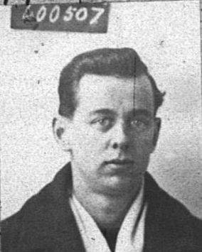
I further found that from 1914 to 1916, he was enrolled at The Glasgow School of Art studying Drawing and Painting, leaving his course in December 1916 to sign up for the Navy. His address then was 9 Minerva Street in Glasgow.

Captain Russell’s Mysterious Second Wife

There’s one final scrap to throw to any genealogical wolves whose previous mild interest in Captain Russell hasn’t by now been utterly sated: a series of slightly confused posts from 2011 on GenesReunited by a poster called “Big” (whose account has since expired).

These relate to Captain Russell’s mysterious second wife Mary Meehan Hamilton: I additionally found a record of them travelling on the motor ship (MS) “Patella” from Curacao to New York in March 1947, which one might suspect was part of their honeymoon.

The poster “Big” seemed to think that Mary Meehan Hamilton was born in 1912, married a Mr Adams in 1924 (yes, really), had seven children (sadly some of whom died from diptheria), was with child when marrying Captain Russell, but married him bigamously under the surname “Cunningham” (her second husband’s surname).

Maybe inside all this morass of detail there’s a four-hour Snyder Cut of Captain Russell’s epic life just itching to be made, who knows?

And next…

Will there be a Part 4 to this story? Right now, I’m kind of hoping there won’t… but still, “never say never“, as they say in showbiz, amiright?

In Part 1, we saw the outlines of how technology converged with Mauritian treasure hunting mania in the 1920s. But what was that technology, and how ultimately did it link in with Mauritius?

“Listening for Coal”

The person behind the sounding technology was a Mr W. Mansfield, and the story behind it appeared (very appropriately, it has to be said) in The Liverpool Echo, 12th June 1924, page 7, under the title: “Listening for Coal / How Liverpool Inventor Finds Seams / Treasure-Hunters Agog. / Story of Hoard Buried by Pirates“. Tiresomely long title aside, I think the article bears quoting in full:

An invention by Mr William Mansfield, of W. Mansfield and Co., engineers, of Liverpool, by means of which not only the position, but the actual shape, of metalliferous deposits deep in the ground may be indicated on the surface, has aroused widespread interest, especially in the mining industry, for which it was particularly intended to apply.

This instrument follows the automatic water and oil finders of the same company, which are being used, it is claimed, with 100 per cent. of success in all parts of the world, and which are supplied on the principle of “no full supply, no pay.”

So, what Mansfield was offering was a kind of echo-sounding technology, which he claimed could be used for many types of prospecting & searching.

In seeking for metals or coal deposits, a very simple electrical device is set up on the surface of the ground, sending a curious musical note through the earth, and a couple of assistants – a man and a boy can carry out the tests – can indicate the presence or absence of what they seek by means of sounders.

Wherever the note is clearly heard the ground is sterile so far as metals or coal are concerned, but when the note diminishes greatly or ceases entirely the indications are that they are walking over deposits. By stepping on and off this cone of partial or complete silence and driving pegs they can outline the form and extent of the deposit, and a simple calculation gives the depth.

News of the invention has greatly increased the enthusiasm of those who believe they know, roughly, where treasure lies buried, and Mr. Mansfield has had many calls from such people.

One treasure hunter had the instrument tested on a piece of ground in Cheshire, where a quantity of metal was buried some twelve feet below a ploughed field. Two men who were entirely ignorant of the position of the “treasure” located the place with precision by means of the automatic finder.

The treasurer[sic]-hunter bought the instrument, and he and a party have taken it to the Spanish Main confident that if they don’t find the doubloons they seek it will be because they are not there.

OK so far: but it’s the final section below that’s arguably the most interesting, because it makes a direct link to Mauritius a couple of years before Captain Russell travelled there (on his doomed treasure hunt):

Mr. Mansfield told an “Echo” reporter that it was child’s play to find a chest of metal a few feet down, and he was too busily occupied with the serious work of which the apparatus was capable to accept all the offers he received to join in expeditions for the discovery of hidden gold and silver which might not exist except in the minds of the seekers.

A letter from the magistrate on the island of Mauritius, in the Indian Ocean, is being looked into, however.

This gentleman, Mr. H. E. Desmarais, and a number of influential friends believe there is £30,000,000 worth of treasure buried on the island, representing booty seized by pirates from British and Spanish vessels well over a hundred years ago.

The proposal made to Mr. Mansfield is that he should locate the treasure for them, and receive a quarter of the find.

In view of the influential backing, Mr. Mansfield is making inquiries. As he points out, if nothing is found, a one-fourth share would not go far to meet his expenses in going out to Mauritius!

By the way, who was H. E. Desmarais?

The above article refers to H. E. Desmarais as a “magistrate”: and indeed Google helpfully supplies links where H. E. (Henri Eugène) Desmarais appears in the Colonial listings as Moka Magistrate for Mauritius (with a salary of 7,000 rupees in the 1890s), having been first appointed there on 1st August 1884.

A family tree on MyHeritage says that Desmarais was born 11 March 1843, and died 22 August 1928. He married Wilhelmina Sophia Henriette Ferdinandine Dancker on 2nd September 1868 in Melbourne: they had ten children. He was the third son of Jean Baptiste Evenor Desmarais, of Port Louis, Mauritius, who himself had been an attorney-at-law. His own law training was as a student of the Middle Temple (18th August 1863): he was called to the bar 30th April 1866.

There is a (paywalled) mention in Alfred North-Coombes’ (1971) book “The Island of Rodrigues” that suggests one of Desmarais’ early appointments was as Rodrigues’ Police Magistrate in 1876.

And finally: in the 1922 Blue Book of the Colony of Mauritius, H. E. Desmarais was listed as receiving (as a retired District Magistrate) a 4,216 rupee pension (79%) since 1913, having then retired “of Old Age”.

All in all, it seems entirely reasonable that Desmarais would have been a member of the Klondyke Syndicate. Incidentally, the mention of his “influential friends” was without doubt a heavy-handed (and deliberate) reference to the “Par nos amis influents, fait toi envoyer dans la Mer des Indes et rends-toi à l’Isle de France, à l’endroit indiqué par mon testament” sentence that appears in letter BN2.

W. Mansfield’s Company & Technology

The 1914 “Who’s Who In Business” includes the following description of W. Mansfield’s company:

Mansfield, W., and Co. Consulting Engineers and Well Boring Engineers, Creewood Buildings, Brunswick Street, Liverpool. Hours of Business: 9.30 a.m. to 6 p.m. Established in 1900 by W. Mansfield, the present principal. Premises: Extensive. Branches: Yenangyat, Promo and Eastern Boronga. Business: Consulting Engineers for many important irrigation projects. Pioneers of Long Staple Cotton Growing in Burma. Owners of Oil and Mineral properties; Well Boring Engineers. Patent: Mansfield’s Automatic Water and Oil Finders. Connection: United Kingdom, Foreign and Colonial. Telephone: No. 1392 Central, Liverpool. Telegraphic Address: ” Mantles, Liverpool.” Codes A B C, Engineering and Private. Bankers: National Provincial Bank of England, Ltd. Mr. W. Mansfield is a member of several Engineering and other Societies. He is interested in Educational questions and has travelled throughout Europe, Asia, and Africa.

From the Grace’s Guide entry on the company, you can see that it was selling its water finder technology by at least 1911. Mansfield’s company later hit the papers in 1931 (10th October, Liverpool Echo, p.13) when a 30-year-old employee sadly got hit on the head and died: and it was still advertising in 1934 (18th July, Liverpool Echo, p.13).

So, what did its metal-finding device look like? Luckily, we don’t have to rely on mere verbal descriptions of Mansfield’s echo-sounding technology, because there are a number of advertisements and articles that contain actual pictures (even if the endorsements that go with them do sound somewhat made-up, it should be added). Here’s a W. Mansfield advert from Chambers’s Journal that sits above an advert for a Dulcitone (which is why the Royal College of Music has a scan of the page on its website):

Coming up next…

In Part 3, I hope to tell a little of the story behind Captain Russell, who led Mansfield’s treasure hunting expedition to Mauritius…

I’ve had some interesting emails recently from Patrick O’Neil, who I’m very pleased to report has picked up my long-dropped baton on Mauritian treasure hunting in the period between the two world wars. By uncovering a number of sources I was unaware of (and with only minor assists from me), Patrick has started to reconstruct a side of this story that was previously only hinted at.

“Treasure Hunting in Mauritius”

An article titled “Treasure Hunting in Mauritius” by James Hornell in the 9th April 1932 edition of “The Sphere” (p.57) vividly sets the scene. The famous Mauritian treasure is none other than Surcouf’s, its author asserts, hidden in a cave “on a lonely stretch of coast”, but never retrieved:

A few years ago a plan giving clues to the position of the cave was brought to Mauritius – once a death-bed legacy ! A syndicate [the “Klondyke Syndicate”] of well-known local people was formed to follow up the clues. It was easy enough to identify the narrow gully or gorge in the cliffs up which Surcouf had carried his loot ; two of the stones marked on the plan were located, one with what seemed to have a letter or figure roughly carved upon it. Hope ran high, but now a check was registered ; no trace of a cave could be found ; it was thought that a landslide had taken place covering the mouth. Trial cuts were made here and there but no progress was made, and when the money subscribed ran out, the work ceased.

Hornell goes on to tell us how the search for the treasure then went ‘hi-tech’:

At a later date negotiations were opened with an engineering firm in England, and under agreement of equal shares to each party, an electrical divining instrument, designed to locate metal, was brought into use. Unfortunately the only spot where the pointer became agitated was over a surface of solid rock. From this it was inferred that the landslip had covered the entrance to the cave to a great depth, and that the spot indicated was above the end where the treasure lay. Weary weeks passed in cutting a way down through dense basalt rock of extreme hardness. Ten feet down they went without success ; then to twenty and on to thirty ; at about thirty-five they struck earth, and this raised their hopes to fever pitch. Immediate success was assured – the earth-filled cave was reached at last ! The island authorities were notified and a detachment of armed police went excitedly down to the gully to afford protection, So sure was the engineer of success that a motor lorry was requisitioned to convey the gold and jewels to the bank.

What happened next? Sadly, the dismal punchline is all too easy to predict:

Alas ! Hard rock soon reappeared and the electric indicator still encouraged further effort downwards in the same spot. Two months later when the depth of the shaft had reached over fifty feet I was invited by the engineer to visit the place. I could but admire his tenacity of purpose in face of prolonged disappointment and his patience in laboriously cutting a shaft through virgin rock with chisel and crowbar, afraid as he was to use explosives.

Incidentally, if you’re wondering who the author of this piece was, I’m pretty sure he was the “internationally well known fish expert and colonial adviser based in India” (and former Director of Fisheries in Madras) James Hornell F.L.S. F.R.A.I. (1865-1949), who wrote numerous books on fish, fishing, fishermen, and fishing boats all the way from Britain to Oceania. And did I mention he was interested in fish?

Anyway, even though this helps us glimpse the big picture, we are still left with many questions. For example: where was this site?

“A spot known as Klondyke”

Helpfully, a column in The Daily News of 13th April 1926 reporting on this story describes the location (albeit somewhat inexactly):

The scene of the search is a spot known as Klondyke, on the west coast of Mauritius, in the Black River district, and the treasure, which has come to be spoken of as the Klondyke treasure, is believed to have been secreted there between 1780 and 1800 by the Chevalier de Nageon, a noted privateer.

Unlike the version of the article that was reproduced in the Brisbane Telegraph (which I typed up here), this includes a rough-and-ready map, with a piratical “X” to mark the (approximate) spot:

The article continues:

A number of attempts have been made, at intervals since 1880, to find the treasure, and excavations were made in accordance with instructions sent to a Mauritian from one of his relatives in Brittany.

Then the Chevalier de Nageon’s own plan was said to have been found, and a company was formed to begin regular diggings.

Some stonework and other clues tallying with the plan were brought to light from time to time, but nothing else happened, and the shares of the Klondyke Company – held by about a score of persons – became temporarily worthless.

But by the end of last December these shares were selling at 5,000 rupees (about £375) each. This was because Captain Russell had come across new indications which gave rise to the highest hopes.

(Incidentally, has anyone ever actually seen a physical share in the Klondyke Company? I’m sure I’m not alone in wanting to have one framed on my wall.)

There was also a mention at the article’s end that “the native diggers, as I hear today, are feverishly excited concerning yet another treasure, supposed to have been hidden by the same Chevalier de Nageon at Pointe Vacoa, Grand Port“. As you’d of course expect, “(f)abulous figures are mentioned in this latest story”: the Mauritian treasure hunting ‘virus’ is one that constantly mutates…

To be continued…

In Part 2, I’ll go on to look a little more closely at the Liverpool engineering company and their strange machine…

Here’s an official document from 1760 from the Mauritian Archives relating to the Nageon de l’Estang family property:

(Click on the image to get a higher resolution JPEG.)

And here’s a transcription very largely provided by Ruby Novacna, with additional parallel transcriptions from Anthony Lallaizon and Thomas below – thanks very much to all three of you for this excellent help!

Rather than modernise the text, my preference (as per Ruby’s excellent work) is to try to stay close to the original spelling, though anyone wanting to grasp what it means might prefer Anthony’s and Thomas’ versions in the comments below:

1. Le conseil Superieur de l’Isle de France a tous Presents et
2. aVenir Salut. Scavoir faisons qu’en consequence des Ordres de
3. la compagnie inseréé dans la deliberation du deux Janvier M
4. Sept cent cinquante trois [i.e. 2nd Jan 1753] et de ladite Deliberation Nous Avons au Nom
5. De Messieurs les Sindics et Directeurs De la Compagnie Des Indes
6. Concedé et Delaissé Concedons et Delaissons Des maintenant et p[our] toujours
7. Par ces presentes au sieur André Nagëon De l’Etang fils Du sieur
8. Bernardin Nagëon Son père De son vivant officier Des Vaisseaux
9. De Côte p[our] la Compagnie ledit André Nagëon Demeurant chez M[a]d[am]e
10. Sa Mere, En ce port et Paroisse Louis a ce present et acceptant P[our] Luy
11. Ces hoirs et ayant cause la propriété D’un terrain De treize toises
12. Deux Pied(s) Delarge Sur Vingt Six toises quatre pied(s) De proffondeur
13. Scitué sur le Rempart De la grande Montagne n[uméro]te 130. Borné D’un
14. Coté par une rue qui conduit alad[i]te montagne Dautre Coté Par…
15. D’un bord un autrerue qui conduit Dans l’Enfoncement et d’autre bout par
(16. Une rue Entredeux)
16. Le Sieur (?)
17. Le tous suivant le plan corigé par M Magon (?) Directeur et Commd[an]t gen[er]al
18. Led[i]t terrain accordéé au S[ieur] Nageon fils par Ordonnance Du Conseil Du
19. Sept may Mil sept cent Soixante [7 May 1760] Pour Par led[i]t Nageon fils Ses enfans
20. Hoirs, ou heritiers meme ceux D’iciluy ayant cause jouir faire et Disposer
21. Dudis terrain comme la chose luy appartenant en toute propriété roturière
22. Et néant moins reconnaitre Messieurs De la Compagnie Des Indes comme
23. Seuls Seigneurs Directs, Suzerains Hauts moyens et Bas justiciers et p[our] ce
24. est sujet atous droits de justice et Banalité quils jugerons a propos D’Etablir
25. Sera tenu ledis Sieur D’Enclore et faire Batir sur ledit terrain de faire
26. Couvrir les Batiments qu’il y fera construire En planches, Bardeaux ou
27. Arg[?] , aux termes presents par les Reglements, s’oblige de payer par
28. annéé sur les ordres et dans les tems qui seront prescrits par le Conseil
29. Douze deniers De premier Cens reputé cens commune et imprescriptible
30. Tant p[our] le fond que pour laquotité lequel Emportera lod(s) et ventes
31. S’aizinnes [saisines] et amendes, au Désir de la coutume de Paris comme aussy
32. D’executer Exactement toutes les Ordonnances et reglements faits et a faire
33. Par la suite par la compag[ni]e ou le Conseil de passer au domaine de la
34. Compag[ni]e. Declaration et reconnaissance dudit terrain et des droits
35. Cy dessus Stipuler le tout a peine de Nullité de la presente Concession De
36. Reunion au domaine Dudit Emplacement Sur le Simple Requisition du
37. Procureur General du Roy Sans estre par la compag[ni]e tenu Daucunes
38. Indemnité. Ny formalité de justice Ny Sans que ladite peine Ny rien
39. Du contenu en la presente Concession Puisse estre reputé comminatoire mais
40. De rigueur étant la condition precise du don gratuit que la compag[ni]e
41. En fait et p(9) que ces presentes ayant leur forces et valeur ou marges
42. D’Expedition d’icelle sera apposéé le sceau de la compagnie des Indes
43. Donné au Port Louis de l’Isle de France le dix de may mil sept cent soix[an]te [i.e. 20 May 1760]
44. Et a Signé
45. Nageondeleteang
46. ? Lejuge ?
47. ?

Oh, and here’s a close-up of the signature at the bottom left, which I read as “Nageondeléteang”, yet another variant spelling to add to the list *sigh*:

In my last Cipher Mysteries post, I floated the idea that when Bernardin Nageon de l’Estang famously wrote that…

j’ai naufragé dans une crique près des Vaquois

… he may have been referring not to the town or inland area called Vacoas, but rather to Pointe de Vacoas on Mauritius’ South-Eastern coast, which was close to the half plot of land he owned. According to his Will (BN1), what Bernardin did immediately after being “shipwrecked in a creek” was:

j’ai remonté une rivière et déposé dans un caveau
les richesses de l'Indus

So: might there be a cave next to a creek not far from Pointe de Vacoas? Generations of Mauritian treasure hunters must surely have put the same two and two together to get the same bejewelled four, right?

But perhaps more importantly, you might be asking what on earth this post has to do with three hundred dead dodos? Has Cipher Mysteries been taken over, as my son asked, by some kind of “ARK: Survival Evolved” meme?

Photo by BazzaDaRambler – Oxford University Museum of Natural History

No, this post is genuinely about treasure and dodos. Really. Read on.

The Creek

Having looked at a fair few historical maps of Mauritius, it seems to my eyes that there was only ever one winding little creek near Pointe de Vacoas. Rather than starting from beside the Point itself (as per the cadastral map I mentioned in the last post)…

…the creek actually starts a little to the side, though it does then indeed kick sideways across towards the Mare du Tabac, which became the Union Vale Sugar Estate:

Source: Mauritius Chamber of Agriculture

In this 1880 map, you can see “Pte Vacoa” in the bottom right leading round to a small river (the “Ruis[seau] des Marres”) that winds its way inland, before finishing up by the Union Vale railway station (at centre left).

Union Vale, 1880 map of Mauritius

OK, while I’m not saying that Ruisseau des Marres is ‘definitely’ the stream / creek that Bernardin was referring to, what I am saying is that it seems (to my eyes) to be a very strong candidate indeed. For if you don’t look there, where else would you to go looking first, hmmm?

Going over the map carefully, you should also be able to see the area around the Ruisseau des Marres is called “LES MARRES”. There are also a couple of odd-looking features on the map labelled as “Mare …”, the right of which is labelled as “Mare aux [something] or Dodo“. Unsurprisingly, we’ll be returning to that location before very long…

The Cave

I first started thinking about Mauritian lava tubes back in 2016, and have never really stopped. This is because Bernardin’s second letter BN2) runs:

l'entrée d'une caverne jadis formé par un bras
de rivière passant sous la falaise et bouchée
par les corsaires pour y mettre leur trésor et
qui est le caveau désigné par mon testament

…which I think sounds exactly like a description of a lava tube.

Here’s a rather nice 1820s drawing by de Sainson of a Mauritian lava tube in the Grande Riviere quartier (not too far away) that I previously mentioned in a separate post:

Though the lava tube or lava blister we’re looking for must surely have been more modestly sized than this epic specimen, it’s the same basic idea.

Mare Aux Songes

In a rather charming 2007 New Yorker article called “Digging For Dodos“, we meet a gaggle of dodo experts and enthusiasts, all inspired by the Mare Aux Songes – a (formerly) boggy pond in the South-East of Mauritius. This site was discovered in 1865 by local teacher George Clarke, after his thirty year search for dodo bones.

In fact, the Mare Aux Songes ended up yielding far more dodo bones (from more than 300 separate dodo skeletons!) than everywhere else combined. Hence even the dodo skeleton at Oxford University Museum of Natural History (yes, the photo at the top of the post) was from the Mare Aux Songes.

In response to a malaria epidemic a few years later, British engineers covered the whole boggy area with concrete to prevent mosquitoes breeding: the Mare Aux Songes then spent most of a century out of reach.

The experts (in the New Yorker article) had formed a group called the 2006 Mauritius Dodo Expedition, with the idea of revisiting the Mare Aux Songes with a more modern scientific approach, to find more about dodos. Specifically, they wondered whether they might find multiple historical layers of dodo remains. But what they actually found was that all the dodo bone fragments seem to have come from a relatively short period around 4000 years ago.

What exactly had happened? The report outlines the group’s conclusions:

The geomorphology of the rock valley, in particular being bounded by steep cliffs, suggests collapse of a pre-existing cavity in the subsurface. In volcanic settings rock valleys generally evolve from the collapse of lava tunnels (e.g. Peterson et al., 1994), and these systems are common in (SW) Mauritius (Middleton, 1995; Saddul, 2002; Janoo, 2005), suggesting that the MAS rock valley was created in a similar way. Therefore at some point after 120 ka, large-scale roof collapse led to the formation of a dry valley at MAS (Fig. 4A).

“Mid-Holocene vertebrate bone Concentration-Lagerstatte on oceanic island
Mauritius provides a window into the ecosystem of the dodo (Raphus cucullatus)”

So, the basic narrative they reconstructed was this:

  • the Mare Aux Songes had started out as a lava blister (i.e. a void inside the volcanic basalt) with a diameter of ten or more meters;
  • the lava blister’s roof had weathered and collapsed, leaving behind an exposed hemispheric ‘bowl’;
  • there had been a long dry period, perhaps across a couple of centuries;
  • during that dry period, a large number of animals (mainly turtles, but a few dodos too) had found themselves trapped inside the steep-walled bowl; and
  • this was where, unable to climb back up its steep walls to escape, the three hundred dodos died.

And you will surely be unsurprised to find that the Mare Aux Songes mentioned on the map above is (or was) the boggy pond that formed in a roofless lava blister about 1km NNW of Pointe de Vacoas (as per the 1880 map).

Local Ponds and Caves in 1838

The best historical source on the geography of the local area I have found so far is the (1838) book “Statistique de l’Ile Maurice et ses dépendances” by M. le Baron d’Unienville.

Helpfully, the Baron lists the ponds (“mares”) of most interest in this quartier (my loose translation) [pp.139-140]:

The Mare la Violette, on Lahausse's land, yields a lot
of water, nevertheless sometimes drying up, but only
very rarely; its waters drain into le Bouchon.

The Mares du Tabac spring from between the Toussaint,
Avice and Buttié plots; they provide eels [anguilles],
shrimps [chevrettes], and water snails [corbeaux]; they
drain out into the Cul du Chaland, towards le Bouchon.

The Anse-Jonchais, Bambous and Albert ponds sometimes
dry up, but all provide very good water.

On M. Fenonillot's land, there is a natural pond three
to four hundred fathoms long by one hundred wide, becoming
up to 25 feet deep in the rainy season, with water springing
from the earth. This pond dries up in the dry season.

Interestingly, the Baron didn’t even consider the Mare Aux Songes to be worth reporting on, presumably because it was so marshy and boggy that you couldn’t get any useful water from it.

But more interestingly, he goes immediately on to discuss the caverns of the quartier (again, please forgive my loose translation) [pp.140-141]:

This district is very cavernous in places, especially towards
the coast going round from Chasur to the point.

In several parts of the Mares-du-Tabac area, the ground
resonates hollowly under the footsteps of men. The artificial
excavations present there the certainty of a great upheaval
formerly caused by underground fires, since in addition to
volcanic stones whose soil is covered, the layers of earth
are firstly topsoil, then tuff [a light, porous rock formed
of volcanic ash], then earth again in unequal layers always
interspersed with volcanic stones.

The Pointe du Souffleur offers a rather singular phenomenon,
also found in other regions; the water pushing violently into
the cavities of this point, emerges in a jet of water rising
to a rather great height through a hole two to three inches
in diameter, with the compressed air producing a noise similar
to that of a strong forge bellows.

There are several excavations in this area that are believed
to go through to the sea, such as the Fanchon hole and the
Maignan hole. The first is located on the Chemin du Port, home
of Sieur Leroux, and the second on the Maignan land. Tests
have been carried out to map the underground routes and
interconnections between these holes; but those tests were
unsatisfactory, because the lack of air causes lights to
be extinguished beyond a certain distance.

Sieur Charroux, among others, spent twenty-four hours lost in
the labyrinths of these caves, and considered himself very
fortunate to find the opening through which he had entered
and which may be twenty feet deep.

All in all, I think there is ample reason to believe that Bernardin Nageon de l’Estang’s description of (what sounds to me like) a lava blister or lava tube beneath a cliff is entirely consistent with the geology of the area around Mare la Violette.

It may sound overly romantic, but it seems certain to me that there are still as yet unmapped voids under the ground; and it might well be that one of these once had a concealed entrance. Perhaps the notion that pirates used these voids is just a campfire story (it wouldn’t be the first or the last): but nonetheless, voids there were.

The Cave Nobody Found

The local landscape circa even 1900 was very different on the surface to how it was circa 1750. Much of the area had been razed for growing sugar cane; estates and railways had been built; marshes had been filled and capped in response to the Epidemics of Mauritius; and so forth.

And so by the time of the great explosion of interest in Mauritian treasure hunting in the early 20th century, the area along the Ruisseau des Mares was probably close to unrecognizable. Not that this probably did anything to stop the grimly determined treasure hunters of the era with their fake maps, rumours, hunches, dynamite and shovels. Who knows what features they blew up in their hunger for buried gold?

Now a large part of the same general zone is being redeveloped by Omnicane – a company formed from Mon Trésor & Mon Désert sugar companies, among others – into the Mon Trésor Airport City project. So perhaps the cave we’re looking for has already been unknowingly flattened and redeveloped ten times over, who can tell?

If (and I happily admit that it’s a big if) Bernardin Nageon de l’Estang’s treasure is still in the cave he left it in nearly three hundred years ago, then the way forward is surely through GPR (ground penetrating radar), tracking along the land beside the eastern bank of the Ruisseau des Mares. But it is (and probably will always be) a needle-shaped void in a lava haystack.

Still, even though it took George Clarke thirty years to find his cache of three hundred dead dodos, who would now say that his search wasn’t worth it? And surely that’s how Mauritian treasure hunters feel (more or less), right?

Even so, rather than hiring a load of GPR equipment, I have to point out that you would (thanks to the French treasure hunting laws that Mauritius inherited) probably be better off instead walking up and down beside that river bank until you fell down a hole into a long lost treasure cave.

As they say in the theatre, break a leg. 😉

Finishing With A Song

It’s rare that you can write a blog post that covers an unsolved historical mystery and yet brings in so many nice historical angles along the way: rarer still that you can do all that and end on a song.

So here’s my cousin Phil Alexander (AKA “Philfy Phil”, recorded at The Goat, St Albans in 2010) with “Dido Dies”, one of his… errrm… cleaner parody songs. The first verse and chorus are about dead dodos, and you already know the tune, so feel free to sing along, you know you want to:

The final dodo walked the earth four hundred years ago
No more flapping wings and croaking; the dodo, yes, has croaked
He’s in the doodoo
He lies extinct
No more delicious in Mauritius
Or at least that’s what I thinkt

Then Salvador Dali died in 1989
With the oddest of moustaches
Like his anti-artist predecessor, Dada
Painting stuff
Did he look back and then realize he’d painted quite enough?
And well… let’s face it, most of it was guff

Dada died, Dali died, da dodo died
D’oh, da dodo died

This “Carte générale” is a really great 18th century map of Mauritius held at the BNF, one that Cipher Mysteries commenter Anthony Lallaizon alerted me to. The BNF shelfmark is “département Cartes et plans, GE C-9307“.

Note that the BNF also has a second map of Mauritius that seems to be an updated copy of the first map, but with the owners’ names [rather than reference numbers into an index] inserted directly into the map. BNF shelfmark: “département Cartes et plans, GE SH 18 PF 219 DIV 2 P 24“. (The plots in this seem to my eyes to be a little more subdivided, which is why I suspect it’s slightly later.)

What is interesting, as Anthony is clearly aware, is that these two maps offer snapshots into the world of Mauritius at around the period we’re interested in (if we’re interested in the Nageon de l’Estang family, that is).

So, let’s dive deep into these maps and see what pearls we can retrieve…

The Nageon Plot

As Indian Ocean treasure hunters have known for over a century, the will signed by “Bernardin Nageon de l’Estang” begins (my rough translation):

I’m about to enlist to defend the motherland, and will without much doubt be killed, so am making my will. I give my nephew the reserve officer Jean Marius Nageon de l’Estang the following: a half-lot in La Chaux River district of Grand-Port, île de France […]

Now, as most people who have ever gone hunting for historical cadastral maps (i.e. maps that show the “extent, value, and ownership of land”, typically so that the owners can be taxed) will tell you, this can be a very hit and miss affair. (Errrm… mostly miss.)

Personally, I’d long ago given up on the faint hope that there might be any actual cadastral map of 18th century Mauritius out there: the best I had hoped to find was a later will referring back to an earlier (long lost) will.

But… what we have in GE C-9307 is indeed a cadastral map, nicely indexed. And in that index, just as sweetly as you could wish for, is “574 Nageon”.

Ah, you may reasonably ask, so where is this Nageon plot in modern-day Mauritius? Well, carefully aligning the map so that we can see (most of) the rivers depicted above, I think we can locate this plot extremely exactly.

Yes, the plot is now part of the runway and plane parking area of Sir Seewoosagur Ramgoolam International Airport, which is Mauritius’ main international airport.

So, it turns out that pretty much everyone who has flown to Mauritius from abroad will have passed directly over the Nageon de l’Estang land before they’ve even got their bag down from the overhead locker.

Which is nice.

Other Names on the Map

Anthony points to other possibly connected names that appear in GE C-9307’s index, such as 571 Pitel and 630 Clergeac.

If you had (quite understandably) forgotten why, a 2016 Cipher Mysteries post flagged that André Ambroise Nageon de l’Estang married “Perrine Clerjean” (which was probably “Clergeac”) in Port Louis on 14th January 1766; and then (after her death) married Mathurine Louise Françoise Pitel in Grand Port on 13th June 1768.

To this illustrious list I’d perhaps add quite a different name to conjure with: 467 Levasseur (there in both maps). (A piratical relation? Or no relation at all? You choose!)

Finally, I also noticed an intriguing detail just along the coast: Pte du Vaquoas (which is still marked as “Pointe Vacoas” on modern maps).

Could this be what Bernardin Nageon de l’Estang was referring to when he wrote:

j’ai naufragé dans une crique près des Vaquois

The reason I ask is that even though Mauritius has a modern town Vacoas-Phoenix (right in the middle of the island, close to Curepipe), that town does not seem to appear in these two 18th century maps at all.

So, could it be that Bernardin was simply referring to Pointe Vacoas? Sadly, because the description then goes on to describe climbing up a cliff…

remonte la rivière, remonte une falaise en allant vers l'Est

…and the area around Pointe Vacoas looks extremely flat, the odds that this is true seem small to me. But even so, I thought I ought to mention it. 😉

I should mention that there’s another André Nageon lurking in a gap in the Nageon de l’Estang timeline (slightly after the others that I covered in parts one to four): and he actually has quite a funky story attached to him. 🙂

André Nageon vs the Monster

There are a number of fleeting mentions of André Ambroise Nageon de l’Estang‘s time in the Seychelles in “Population et vie quotidienne aux Seychelles sous le premier empire” by Joël Eymeret, in “Revue française d’histoire d’outre-mer” Année 1984, Volume 71, Numéro 262, pp. 5-29.

But given that André Ambroise Nageon de l’Estang died in 1798, it must surely be his son about whom a particular anecdote was told. Eymeret repeats the tale, but it actually first appeared in “FRAPPAZ, Les voyages du lieutenant de vaisseau Téophile Frappasz dans les mers des Indes”, texte publié et annoté par Raymond Decary, in-8°, Tananarive, 1939, pp.108-109:

C’est ainsi qu’André Nageon passe dans la légende : Créole de haute stature et d’une force prodigieuse, faisant défricher les terres il y a environ quinze ans [c’est-à-dire en 1803] il s’éloigna un peu des travailleurs pour sonder un marais. A peine eut-il commencé son opération qu’un gros cayman, caché dans les roseaux se dressa sur sa queue, pour s’élancer sur lui. L’apercevoir, deviner son intention et le saisir à bras le corps fut pour l’intrépide M. Nageon l’affaire d’une seconde : et luttant ainsi avec son terrible adversaire, il sut maintenir l’égalité du combat jusqu’à ce que des noirs accourus à ses cris, l’eussent aidé à terrasser le monstre qu’il avait combattu avec tant de courage

…i.e. (my free translation)…

It is thus that André Nageon passes into legend: a tall [white] Creole of prodigious strength, while clearing land there about fifteen years ago [i.e. in 1803] he went a small way away from the other workers to survey a marsh. As soon as he started his work, a big cayman, hidden in the reeds, lifted itself by its tail to jump on him. Noticing it, guessing its intention and wrapping his arms around its body took the intrepid Mr. Nageon no more than a second: and it was in this manner, struggling with his terrible opponent, that he managed to keep it at bay until the blacks, having flocked to his cries, helped defeat the monster he had fought against so bravely.

But this is surely the same André Nageon de l’Estang who is mentioned as selling some land in 1815 on Henri Maurel’s site (through which all manner of genealogical goodness flows):

Le 5 Octobre 1815, Antoine [Maurel] fait l’acquisition de André NAGEON DE l’ETANG de deux parcelles de terrain à Victoria.

And so the Seychellois Nageon de l’Estang family marched forward from there to the modern day, one can only presume. 😉

One of the intriguing (yet annoyingly hard to pin down) parts about the third Bernardin Nageon de l’Estang letter BN3 (that I have argued was probably written by an as-yet-unidentified French corsair some 60 years after BN1 and BN2) is the claimed link to Napoleon Bonaparte.

As the letter-writer puts it:

Avec la bienveillance que le Premier Consul m’a témoigné après un fait d’armes glorieux, je serais parvenu

…which is to say (in English)…

With the benevolence the First Consul showed me after a glorious feat of arms, I had hoped to return [to France].

There’s actually a lot of historical timing data implicit here. Napoleon Bonaparte was Premier Consul during the period of the French Consulate (from 12th December 1799 to 18th May 1804): and it was during this period that he instituted various ways of rewarding the brave. Hence the most straightforward inference from the line in the BN3 letter would indicate that the letter-writer was honoured by Napoleon during this period (when he was Premier Consul).

However, we also know that the letter-writer was a seaman: and it wasn’t until 9th August 1801 that Napoleon started to honour bravery at sea, specifically by giving haches d’abordage d’honneur (‘boarding axes of honour’). The last ever three haches were awarded on 24th September 1803, after which date the nation’s bravest seamen were instead inducted in the Légion d’honneur by way of a thank-you-for-not-quite-dying-on-our-collective-behalf.

Just so you know, the haches themselves looked like this, and were engraved with the recipient’s personal details:

Recently, I spent some time trying to work out if the letter-writer might have been in the état-major of Capitaine Jacques Perroud (one of the last three hache d’abordage recipients – and, for what it’s worth, I’m now almost certain that he wasn’t).

But while doing so, it struck me that we might instead be able to tackle this whole problem backwards. That is, I wondered if we could build up a list of all the people who received a hache d’abordage d’honneur, because this unknown person’s name might well be on that list, right in front of us.

The 53 haches d’abordage d’honneur

And so that’s exactly what I did: and have just now posted my list of all the hache d’abordage d’honneur recipients I could find to the Cipher Foundation website. However, of the 53 supposed recipients, I was only able to find 50, despite painstakingly cross-referencing my list against several other lists.

Usefully, though, short biographies of almost all the recipients appear in the historical record (the published Fastes, etc): which means that we can eliminate as candidates all these heroic French seamen whose marine resumes fail to match other details we know about the letter-writer.

And yet… now that I’ve ground my way through the biographies of the fifty listed recipients, I can honestly say that I don’t think the corsair who wrote BN3 is included there.

I’ve also gone through many more biographies of seamen inducted into the Légion d’honneur between 24th September 1803 (the date when the final three haches were awarded) and 18th May 1804 (when Napoleon ceased to be Premier Consul), and haven’t found anything. In fact, it’s hard not to notice that nobody (apart from Capitaine Jacques Perroud) who sailed in the Indian Ocean seems to have been honoured for their bravery during this period.

So this whole research avenue is, unfortunately, starting to look like a bit of a cul-de-sac: if the letter-writer was indeed rewarded by the “Premier Consul”, then unless he was one of the supposed missing three recipients (whose names I haven’t yet identified), I can’t obviously see who he was. Which is a huge shame, but it is what it is.

Because the Bernardin Nageon de l’Estang papers manage to combine specificity and vagueness in such a frustrating way, some people like to conclude that they must be outright fakes, or (at best) false elaborations woven from fragments of real events – and that we therefore stand no chance of ever getting to the truth, because whatever truth there is to be had is merely ethereal. Chasing this, then, would be not unlike trying to grasp a cloud.

Personally, I’m not even slightly convinced by this kind of reasoning, no matter how often I see it floated. The flaw in the argument is that historical evidence is rarely as neat and tidy as novelists would like: people don’t leave unambiguous digital trails behind them, real life is messy. And the more you work with the random evidential slurry to be found in archives, the more you’ll hold this to be axiomatically true.

The most genuinely productive stance to take is to instead assume that there is some ordering principle – some tangled, confounded rationality – in play, but that it just happens to sit beyond our current reach.

And so the best response is a combination of humility and patience, two hugely unfashionable qualities in these brash, attention-deficient days: persist with the specifics and keep on keeping on.

The Dying Captain

So: who was the unnamed corsair captain who handed the Missing Corsair the documents describing the location of the pirate treasure from his deathbed? The third (BN3) letter reads:

In my adventurous life before embarking on the Apollon, I was one of those pirates who did so much harm to our enemies Spain and England. We made many splendid captures from them, but at our last battle with a large British frigate on the shores of Hindustan, the captain was wounded and on his deathbed confided to me his secrets and his papers to retrieve considerable treasure buried in the Indian Ocean; and, having first made sure that I was a Freemason, asked me to use it to arm privateers against the English.

Until recently, the best candidate I had was Malroux, a corsair captain who died in a sea battle in the Indian Ocean at the right kind of time: but I had to admit that there were plenty of problems with him as a proposed match. For a start, the sea-battle where he died wasn’t really off the coast of India; and the ship Malroux faced (though English) wasn’t really a “large […] frigate”.

But perhaps I now have a better candidate…

François-Thomas Le Même

Because I’ve been reading Charles Cunat’s mentions of Joachim Vieillard in the last few days, I also took a look through his book on St Malo seamen’s derring do: “St. Malo, illustré par ses Marins”. And there I found a corsair whose story echoes that of the Dying Captain. And then immediately wondered why I hadn’t considered him before, despite having read about him in H.C.M.Austen’s “Sea Fights and Corsairs of the Indian Ocean”. 😮

Though François-Thomas Le Même had made a fortune as an effective corsair, he then managed to lose the lot as an ineffective businessman. Which is why 1804 found him back as the captain of La Fortune (“18 guns of 8, and six carronades of 12”, says Austen), picking off a long series of easy prizes in the Indian Ocean. However, his ship was then run down off the coast of Gujarat by the large British frigate HMS Concorde (Captain Wood, 48 guns), and forced to lower its flag after one (Austen) or ten (Cunat) hours’ battle. The ship and its crew were taken to Bombay, arriving on 13th November 1804.

Incidentally, here’s a Mauritian stamp depicting him:

le-meme-stamp

Austen continues (p.106):

“Lemême and all his principal officers were dispatched in the [East Indiaman] Walthamstow on 15th February, 1805, to England, under the escort of the frigates Concord[e] and Phaeton. Lemême’s career, however, was over. He died at sea on 30th March, in latitude 10 south and longitude 77 east.”

Cunat colourfully describes Le Même’s death throes (p.410):

“Appelant aussitôt près de lui ses intimes d’entre ses compagnons de captivité, il les entretint de sa famille, de deux filles chéries qu’il ne devait plus revoir, de celle surout qui devint plus tard l’épouse de capitaine de vaisseau [Vincent] Moulac. Il exprima ses regrets à quitter la vie avant d’avoir pu rétablir sa fortune, dans l’intérêt de ses enfants, puis, interrompu par une crise affreuse, il cessa de parler et perdit connaissance. On le crut mort… Il revint cependant à lui, assez de temps pour faire ses adieux à ceux qui l’entouraient, et rendit le dernier soupir avec le courage et la résignation d’un homme de bien.”

Gallois adds that Le Même’s officers also being taken to England on the Walthamstow were “Charpentier, Froussart, Bourdais et Baudot”: all of which pretty much concludes our romp through what is a fairly sparse evidential landscape.

Interestingly, though, La Fortune‘s prize papers are in the National Archives (HCA 32/1026/1859), as is HMS Concorde’s captain’s log covering the action (ADM 51/1529). In addition, the East Indiaman Walthamstow’s papers are in the British Library (L/MAR/B/196), so there’s still plenty of room for exploration of this research lead just yet…

“AFAHMAEP”, perhaps?

Perhaps you’ve already figured out where I’m going with this.

What I’m wondering is that whereas the Voynich Manuscript needed an Emperor-sized fool to buy it to ensure its survival against the inquietudes of Time and Space, might it be that Le Même performed the same function for the Nageon de l’Estang papers?

That is, might someone have sold Le Même – during the couple of years in Mauritius when he was unbelievably flush with cash – the original set of Bernardin Nageon de l’Estang papers? Austen notes (p.104):

“Equipped with money [1,400,000 francs], but unfortunately without experience, he set up as a merchant-banker in Port-Louis. He very quickly discovered that he was no match for the local sychophants [sic] and sharpers who quickly surrounded him. In the year or two he had practically lost all his savings.”

The notion that a Mauritian sharper saw his chance to unload a “treasure map” on Mr Did-You-Hear-They’ve-Taken-Gullible-Out-Of-The-Dictionary does have an awful ring of truth to it. Which is not to say that the other BN documents are necessarily genuine or necessarily false, but rather that this might well have been the point when someone sold them to Le Même as if they were genuine.

Acronymically, “A Fool And His Money Are Easily Parted”, indeed.

Sources on Le Même

Austen’s account (pp.102-106) “is drawn up from the following sources : M. Gallois, Col. Malleson, St. Elme le Duc and [Charles] Cunat, and is believed to be as accurate as the lack of authentic information and variety of authorities permit it to be.”

* Charles Cunat. “St. Malo, illustré par ses Marins” (1857) [pp.403-410]
* St Elme le Duc. “Ile de France : Documents pour servir à son histoire civile et militaire” (reprinted 1925)
* Colonel G.B. Malleson. “Final French Struggles in India and on the Indian Seas” (1884) [pp.101-106]
* Gallois, Napoléon. “Les Corsaires français sous la République et l’Empire [Volume 2]” (1847) [pp.325-332]

I don’t believe that le Duc’s account is available anywhere online, but perhaps someone will point me to it behind a Geneanet paywall etc. 🙂

Cipher mysteries usually offer us multiple bubbles of probability to work with, e.g. whether the Somerton Man was Charles Mikkelsen (close but no cigar, despite the former’s nicotine-stained fingers), or even poor old H. C. Reynolds (and what a waste of time that bubble was, eh?). Yet these bubbles tend to be fragile and elusive, and we catch only indirect glimpses of them through the cracked mirrors of historical archives. For would not future historians also struggle to pin down and reconcile the vagaries and scattered events of our own tangled lives?

And so it was that while trying to reconstruct the history of Joachim Vieillard before his time on Robert Surcouf’s La Confiance, I took another look at Lhermitte’s ship La Preneuse, because Louis Garneray said that Vieillard had been on it. (Of course, though we can’t take anything attributed to Garneray as a fact in and of itself, we can use it as a stepping stone to point us in a plausible direction to look for genuinely verifiable evidence.)

In case you’re still not sufficiently steeped in Indian Ocean maritime history, La Preneuse sank in the Battle of Port Louis on 11th December 1799: you can buy a halfway-decent print of Garneray’s painting here:

la-preneuse

Anyway, while going through all that, it struck me that BN3’s Captain “Hamon” / “Harmon” could feasibly have been not Captain Hamelin (as I have long suspected, and which lead pointed me in the direction of Vieillard) but instead Captain Lhermitte. And I thought I ought to look a little closer…

Jean-Marthe-Adrien Lhermitte

Though the linguistic match is admittedly a little worse, the timing is better – for by the time Hamelin and the others were inducted into the Légion d’Honneur in 1810, Napoleon was no longer the “Premier Consul” but “Sa Majesté” or “l’Empereur”.

After being defeated at the Battle of Port Louis, Lhermitte was (along with a good number of his men) captured by the British and returned to France. Subsequently, Lhermitte was brought to the Tuileries in October 1801 and honoured in the highest terms by Napoleon. Henceforth he would be referred to as “Lhermitte le Brave“. Which is nice.

So… might someone sailing under Lhermitte have also been honoured by Premier Consul for his part in the same naval action, in the same way that Joachim Vieillard and various other valiant enseignes de vaisseau were made Chevalier of the Légion d’Honneur in December 1810? It’s certainly possible, though I have to say that there’s a distinct lack of external documentation to be found.

Further, one might possibly try to reason (from the lack of reference to “Chevalier” etc in BN3, though I admit that this is still a little bit of a stretch) that whatever event was being referred to, it happened after the position of Premier Consul was put in place (17 November 1799) and also probably after when weapons of honour were first “awarded as military awards for feats of arms” (25 December 1799), and yet before the Légion d’Honneur itself was founded (in 1802, replacing weapons of honour). Which is quite a narrow window. 🙂

Remember that BN3 says:

“Avec la bienveillance que le premier consul m’a témoigné, après un fait d’armes glorieux, je serais parvenu.”

Hence I think it is entirely possible that the person who wrote BN3 received a weapon of honour from Napoleon, and was thus made a légionnaire (though not yet a Chevalier, because that naming style only began in 1802).

Interestingly, the Wikipedia page on weapons of honour says that “recipients […] automatically received the Legion of Honour after its inception”. For example, Lhermitte was made an early member of the Légion d’Honneur for that specific reason.

Lhermitte’s record there is LH/1632/62 (his date of birth is 1766/09/29), which says that he was upgraded to Chevalier on 5th February 1804, and then swiftly to Officier on 14th June 1804.

So… we have a date to look for, it would seem.

5th February 1804

On a webpage entitled “Pierre Callens, Le dernier Corsaire Dunkerquois“, we find a corsair “Qui fut décoré de la Légion d’Honneur sous le numéro 280 le 5 Février 1804, 15 Pluviôse An XII de la République” listed by Pierre Van Eccloo in 1996:

L’HERMIT[T]E qui commande à bord a pour second DEHAU, Pierre PLUCKET Lieutenant de Vaisseau, Pierre CALLENS Enseigne de Vaisseau, Pierre AUDIBERT Aspirant. Ce sont des “durs”. Une grande aventure commence.

(Though note Pierre Callens was listed with a later date in the Leonore database, which is a little confusing.) However, if you look a little more closely, you’ll see that these people were on le Tigre under Lhermitte, and that they seem not to have sailed to the Indian Ocean with him.

What’s more, if you do a websearch for “15 pluviôse an XII” or “5 fevrier 1804” with related keywords, you’ll rapidly find plenty of other French mariners people who were made Chevaliers on that same day, e.g.
* Louis-Antoine-Cyprien Infernet (1757–1815)
* André Jules François de Martineng (1776-1860)
* Yves Marie Gabriel Pierre LE COAT, baron de SAINT-HAOUEN (1756-1826)
* Guy Pierre de Coëtnempren, comte de Kersaint (1747-1822)
* Claude Vincent Polony (1756/1828)
* Pierre-François Violette (1759-1836)
* Pierre-Paulin Gourrege (1749–1805)
* Jacques Épron des Jardins
* Théodat Jean-Baptiste Le Bastier de Rivry (1785-1829)

…none of whom seems to have served with Lhermitte, unfortunately. So we still have plenty to look at here before we can properly evaluate whether or not this is a workable bubble to be examining (or indeed popping). Oh well!