This “Carte générale” is a really great 18th century map of Mauritius held at the BNF, one that Cipher Mysteries commenter Anthony Lallaizon alerted me to. The BNF shelfmark is “département Cartes et plans, GE C-9307“.
Note that the BNF also has a second map of Mauritius that seems to be an updated copy of the first map, but with the owners’ names [rather than reference numbers into an index] inserted directly into the map. BNF shelfmark: “département Cartes et plans, GE SH 18 PF 219 DIV 2 P 24“. (The plots in this seem to my eyes to be a little more subdivided, which is why I suspect it’s slightly later.)
What is interesting, as Anthony is clearly aware, is that these two maps offer snapshots into the world of Mauritius at around the period we’re interested in (if we’re interested in the Nageon de l’Estang family, that is).
So, let’s dive deep into these maps and see what pearls we can retrieve…
The Nageon Plot
As Indian Ocean treasure hunters have known for over a century, the will signed by “Bernardin Nageon de l’Estang” begins (my rough translation):
I’m about to enlist to defend the motherland, and will without much doubt be killed, so am making my will. I give my nephew the reserve officer Jean Marius Nageon de l’Estang the following: a half-lot in La Chaux River district of Grand-Port, île de France […]
Now, as most people who have ever gone hunting for historical cadastral maps (i.e. maps that show the “extent, value, and ownership of land”, typically so that the owners can be taxed) will tell you, this can be a very hit and miss affair. (Errrm… mostly miss.)
Personally, I’d long ago given up on the faint hope that there might be any actual cadastral map of 18th century Mauritius out there: the best I had hoped to find was a later will referring back to an earlier (long lost) will.
But… what we have in GE C-9307 is indeed a cadastral map, nicely indexed. And in that index, just as sweetly as you could wish for, is “574 Nageon”.
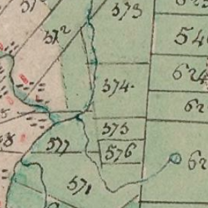
Ah, you may reasonably ask, so where is this Nageon plot in modern-day Mauritius? Well, carefully aligning the map so that we can see (most of) the rivers depicted above, I think we can locate this plot extremely exactly.
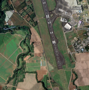
Yes, the plot is now part of the runway and plane parking area of Sir Seewoosagur Ramgoolam International Airport, which is Mauritius’ main international airport.
So, it turns out that pretty much everyone who has flown to Mauritius from abroad will have passed directly over the Nageon de l’Estang land before they’ve even got their bag down from the overhead locker.
Which is nice.
Other Names on the Map
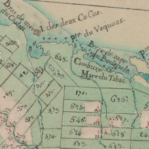
Anthony points to other possibly connected names that appear in GE C-9307’s index, such as 571 Pitel and 630 Clergeac.
If you had (quite understandably) forgotten why, a 2016 Cipher Mysteries post flagged that André Ambroise Nageon de l’Estang married “Perrine Clerjean” (which was probably “Clergeac”) in Port Louis on 14th January 1766; and then (after her death) married Mathurine Louise Françoise Pitel in Grand Port on 13th June 1768.
To this illustrious list I’d perhaps add quite a different name to conjure with: 467 Levasseur (there in both maps). (A piratical relation? Or no relation at all? You choose!)
Finally, I also noticed an intriguing detail just along the coast: Pte du Vaquoas (which is still marked as “Pointe Vacoas” on modern maps).
Could this be what Bernardin Nageon de l’Estang was referring to when he wrote:
j’ai naufragé dans une crique près des Vaquois
The reason I ask is that even though Mauritius has a modern town Vacoas-Phoenix (right in the middle of the island, close to Curepipe), that town does not seem to appear in these two 18th century maps at all.
So, could it be that Bernardin was simply referring to Pointe Vacoas? Sadly, because the description then goes on to describe climbing up a cliff…
remonte la rivière, remonte une falaise en allant vers l'Est
…and the area around Pointe Vacoas looks extremely flat, the odds that this is true seem small to me. But even so, I thought I ought to mention it. 😉
Thank you Nick,.
Hi Nick, here you will find a piece of the history of Sainte Mary Island. You will see
the name of Nageon de L’estang. In july 1750, the queen Bety give her isnland to the french kingdom. And we can can see that nageon de l’estang is a signatory on the “contract”
https://gallica.bnf.fr/ark:/12148/bpt6k5781372q/f37.image.r=nageon%20de%20l'estang?rk=21459;2
in page 24 Histoire et géographie de Madagascar depuis la découverte de l’île en 1506 jusqu’au récit des derniers événements de Tamatave, par M. Macé Descartes [H. d’Escamps],… Descamps, Henri (1815-1891). Auteur du texte
I thank you again to have shared the two maps.
Anthony: I have a nice set of specifically Mauritian documents relating to the Nageon de l’Estang family, which I really ought to post here.
Great!!!
Are you interested if i send you my “miroir du monde” of 7 of july 1934 (number 227). If you are, you can give me your postal adress via email and i will do it with pleasure (for free of course). It will complete the different authors you’ve compiled already on your site (Charroux, de la Roncière etc…).
I’ve just wrote a email to a website that affirms there was a capitaine (corsaire) named nageon de l’estang in 1799 (we’ve already talked about it.). I’m waiting for a answer.
I will share the answer if it’s “positive”
lallaizon anthony: I would of course be interested to see your “miroir du monde”, I’ll email you separately about that. Let me see what I can post of the Mauritian documents this weekend…
lallaizon anthony: I should of course add that the odds that “there was a capitaine (corsaire) named nageon de l’estang in 1799” are precisely zero, but feel free to ask people for the evidence they don’t have. :-p
https://gallica.bnf.fr/ark:/12148/bpt6k65636306/f21.item.r=nageon%20%20nageons
Here we can find the same story (i.e the queen Béti giving her island to the king of France) . And here, we discover that nageon de l’estang is just called Nageon and the fact too, that he was second-lieutenant (on the boat the Mars probably)
Anthony Lallaizon: I presume you’ve seen this page – http://ciphermysteries.com/2016/10/01/nageon-family-part-1-andre-nageon-de-lestang
Yes i’ve seen almost everything on your site concerning “this affair”. My reference to the queen Beti, is just a detail. But it seems that nageon died few montes later. And was “only” second lieutenant”. If we’re supposing that it’s andré bernardin.
The person to whom i ve written a mail has given me his source:
Voici ce que j’ai au sujet de Nageon de l’Estang (Butin), here’s his answer
“Capitaine corsaire fatigué de naviguer s’engagea en 1799 dans l’armée de terre. Il aurait trouvé en Océan Indien vraisemblablement à Madagascar un trésor de pirate. Il fit enregistrer au notaire des Seychelles une déclamation disant qu’il avait enfoui ce trésor dans cette île
( Historia N°370bis).”
Cette information est tiré du fond Alquier trouvé aux archives nationales de la Marine à Vincennes. Mais peut-être vous pourriez vous procurer un exemplaire du N°d’Historia.
I’ve found a document concerning “a” nageon to the “archive de marine à Vincennes” but i can’t read it. i’ve to write to the service. I will do it.
lallaizon anthony: here’s a copy on sale – https://www.amazon.fr/Historia-n%C2%B0-370bis-milliards-d%C3%A9couverts/dp/B003DQYIJC
Hello Nick,thank you: i’ve bought it (few seconds ago) and wil read it and wil send you with “the miroir du monde” if you are ok.
I have to contact “archive de la marine à Vincennes” to solve (settle?) the reality (or the mistake) of that idea.
I know the odds are nearly zero (exactly zero perhaps), but i’m stubborn (I’m from Britanny, people here are known for that trait : stubborn as a Breton 🙂 )
hi nick
just a remark on the levasseur-name on the maps: the owner of that land was a man called pierre-louis levasseur. he came to isle the france in 1726. when the voyage started in 1724 he was 15 years old. so he must have been born in 1709 (not as mentioned in the familiy tree in 1717) in paris, so it’s not very likely that he was a relative of olivier levasseur (la buse), who was born in calais.
https://gw.geneanet.org/hmaurel?lang=en&p=pierre+louis&n=levasseur
https://www.memoiredeshommes.sga.defense.gouv.fr/fr/_depot_mdh/_depot_images/INDES/SHDLORIENT/TABLESPDF/ROLE2P22-I.8.PDF
Daniel: I didn’t suggest Levasseur seriously! :-p
Here’s younger cadastral map (1880) in which we can find “pitel” (twice) near river “la chaux” and “pointe des vacoas”. It’s not very useful but the map is well done.
http://www.depalmas-france.com/MAURITIUS/MAPS/Descubes_Maurice1880.JPG