In my last Cipher Mysteries post, I floated the idea that when Bernardin Nageon de l’Estang famously wrote that…
j’ai naufragé dans une crique près des Vaquois
… he may have been referring not to the town or inland area called Vacoas, but rather to Pointe de Vacoas on Mauritius’ South-Eastern coast, which was close to the half plot of land he owned. According to his Will (BN1), what Bernardin did immediately after being “shipwrecked in a creek” was:
j’ai remonté une rivière et déposé dans un caveau
les richesses de l'Indus
So: might there be a cave next to a creek not far from Pointe de Vacoas? Generations of Mauritian treasure hunters must surely have put the same two and two together to get the same bejewelled four, right?
But perhaps more importantly, you might be asking what on earth this post has to do with three hundred dead dodos? Has Cipher Mysteries been taken over, as my son asked, by some kind of “ARK: Survival Evolved” meme?
No, this post is genuinely about treasure and dodos. Really. Read on.
The Creek
Having looked at a fair few historical maps of Mauritius, it seems to my eyes that there was only ever one winding little creek near Pointe de Vacoas. Rather than starting from beside the Point itself (as per the cadastral map I mentioned in the last post)…
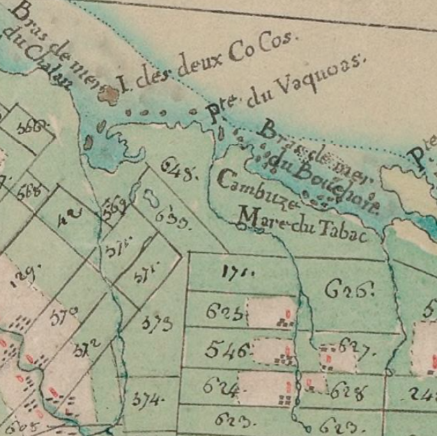
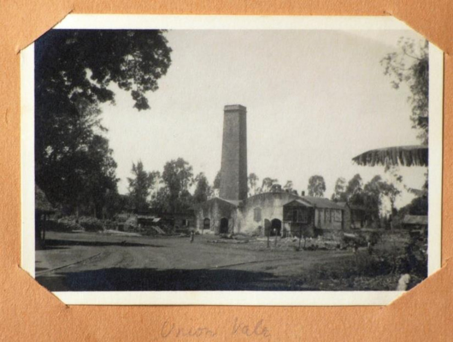
…the creek actually starts a little to the side, though it does then indeed kick sideways across towards the Mare du Tabac, which became the Union Vale Sugar Estate:
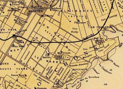
In this 1880 map, you can see “Pte Vacoa” in the bottom right leading round to a small river (the “Ruis[seau] des Marres”) that winds its way inland, before finishing up by the Union Vale railway station (at centre left).
OK, while I’m not saying that Ruisseau des Marres is ‘definitely’ the stream / creek that Bernardin was referring to, what I am saying is that it seems (to my eyes) to be a very strong candidate indeed. For if you don’t look there, where else would you to go looking first, hmmm?
Going over the map carefully, you should also be able to see the area around the Ruisseau des Marres is called “LES MARRES”. There are also a couple of odd-looking features on the map labelled as “Mare …”, the right of which is labelled as “Mare aux [something] or Dodo“. Unsurprisingly, we’ll be returning to that location before very long…
The Cave
I first started thinking about Mauritian lava tubes back in 2016, and have never really stopped. This is because Bernardin’s second letter BN2) runs:
l'entrée d'une caverne jadis formé par un bras
de rivière passant sous la falaise et bouchée
par les corsaires pour y mettre leur trésor et
qui est le caveau désigné par mon testament
…which I think sounds exactly like a description of a lava tube.
Here’s a rather nice 1820s drawing by de Sainson of a Mauritian lava tube in the Grande Riviere quartier (not too far away) that I previously mentioned in a separate post:
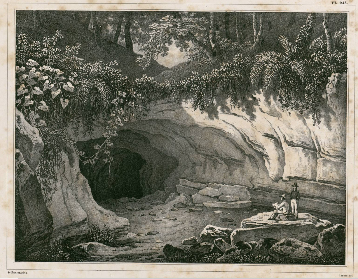
Though the lava tube or lava blister we’re looking for must surely have been more modestly sized than this epic specimen, it’s the same basic idea.
Mare Aux Songes
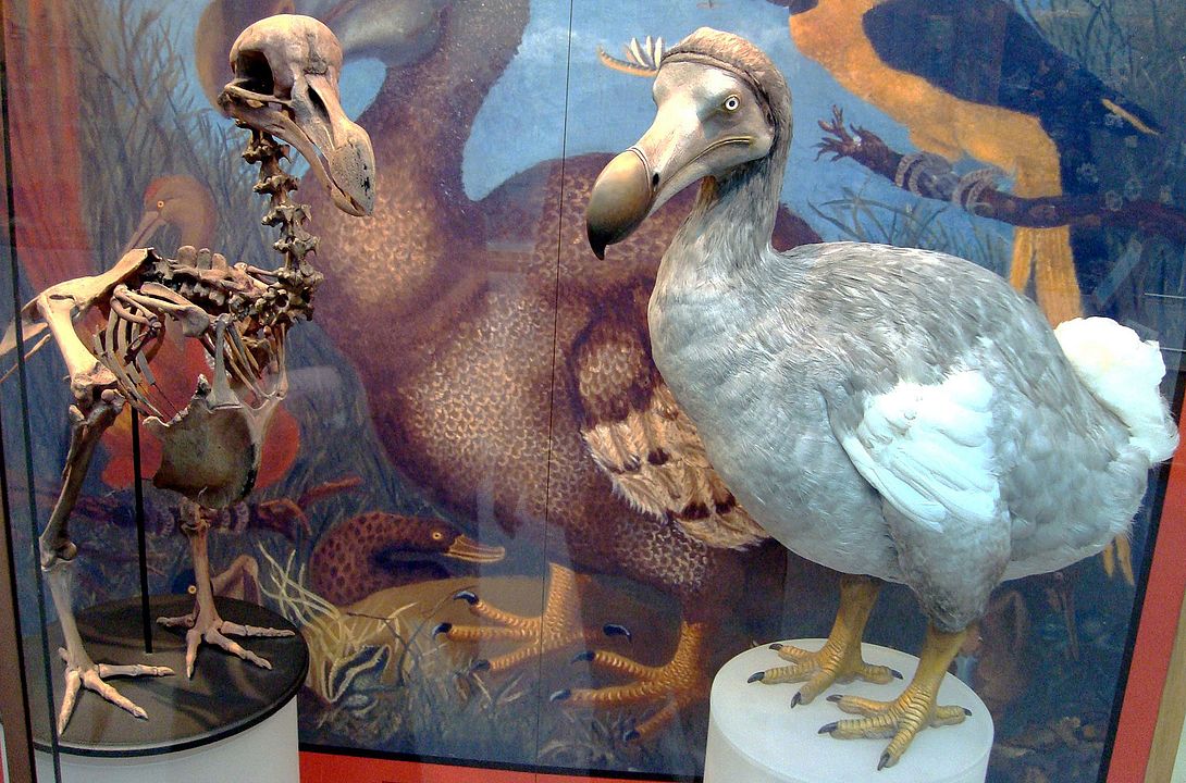
In a rather charming 2007 New Yorker article called “Digging For Dodos“, we meet a gaggle of dodo experts and enthusiasts, all inspired by the Mare Aux Songes – a (formerly) boggy pond in the South-East of Mauritius. This site was discovered in 1865 by local teacher George Clarke, after his thirty year search for dodo bones.
In fact, the Mare Aux Songes ended up yielding far more dodo bones (from more than 300 separate dodo skeletons!) than everywhere else combined. Hence even the dodo skeleton at Oxford University Museum of Natural History (yes, the photo at the top of the post) was from the Mare Aux Songes.
In response to a malaria epidemic a few years later, British engineers covered the whole boggy area with concrete to prevent mosquitoes breeding: the Mare Aux Songes then spent most of a century out of reach.
The experts (in the New Yorker article) had formed a group called the 2006 Mauritius Dodo Expedition, with the idea of revisiting the Mare Aux Songes with a more modern scientific approach, to find more about dodos. Specifically, they wondered whether they might find multiple historical layers of dodo remains. But what they actually found was that all the dodo bone fragments seem to have come from a relatively short period around 4000 years ago.
What exactly had happened? The report outlines the group’s conclusions:
The geomorphology of the rock valley, in particular being bounded by steep cliffs, suggests collapse of a pre-existing cavity in the subsurface. In volcanic settings rock valleys generally evolve from the collapse of lava tunnels (e.g. Peterson et al., 1994), and these systems are common in (SW) Mauritius (Middleton, 1995; Saddul, 2002; Janoo, 2005), suggesting that the MAS rock valley was created in a similar way. Therefore at some point after 120 ka, large-scale roof collapse led to the formation of a dry valley at MAS (Fig. 4A).
“Mid-Holocene vertebrate bone Concentration-Lagerstatte on oceanic island
Mauritius provides a window into the ecosystem of the dodo (Raphus cucullatus)”
So, the basic narrative they reconstructed was this:
- the Mare Aux Songes had started out as a lava blister (i.e. a void inside the volcanic basalt) with a diameter of ten or more meters;
- the lava blister’s roof had weathered and collapsed, leaving behind an exposed hemispheric ‘bowl’;
- there had been a long dry period, perhaps across a couple of centuries;
- during that dry period, a large number of animals (mainly turtles, but a few dodos too) had found themselves trapped inside the steep-walled bowl; and
- this was where, unable to climb back up its steep walls to escape, the three hundred dodos died.
And you will surely be unsurprised to find that the Mare Aux Songes mentioned on the map above is (or was) the boggy pond that formed in a roofless lava blister about 1km NNW of Pointe de Vacoas (as per the 1880 map).
Local Ponds and Caves in 1838
The best historical source on the geography of the local area I have found so far is the (1838) book “Statistique de l’Ile Maurice et ses dépendances” by M. le Baron d’Unienville.
Helpfully, the Baron lists the ponds (“mares”) of most interest in this quartier (my loose translation) [pp.139-140]:
The Mare la Violette, on Lahausse's land, yields a lot
of water, nevertheless sometimes drying up, but only
very rarely; its waters drain into le Bouchon.

The Mares du Tabac spring from between the Toussaint,
Avice and Buttié plots; they provide eels [anguilles],
shrimps [chevrettes], and water snails [corbeaux]; they
drain out into the Cul du Chaland, towards le Bouchon.

The Anse-Jonchais, Bambous and Albert ponds sometimes
dry up, but all provide very good water.

On M. Fenonillot's land, there is a natural pond three
to four hundred fathoms long by one hundred wide, becoming
up to 25 feet deep in the rainy season, with water springing
from the earth. This pond dries up in the dry season.
Interestingly, the Baron didn’t even consider the Mare Aux Songes to be worth reporting on, presumably because it was so marshy and boggy that you couldn’t get any useful water from it.
But more interestingly, he goes immediately on to discuss the caverns of the quartier (again, please forgive my loose translation) [pp.140-141]:
This district is very cavernous in places, especially towards
the coast going round from Chasur to the point.

In several parts of the Mares-du-Tabac area, the ground
resonates hollowly under the footsteps of men. The artificial
excavations present there the certainty of a great upheaval
formerly caused by underground fires, since in addition to
volcanic stones whose soil is covered, the layers of earth
are firstly topsoil, then tuff [a light, porous rock formed
of volcanic ash], then earth again in unequal layers always
interspersed with volcanic stones.

The Pointe du Souffleur offers a rather singular phenomenon,
also found in other regions; the water pushing violently into
the cavities of this point, emerges in a jet of water rising
to a rather great height through a hole two to three inches
in diameter, with the compressed air producing a noise similar
to that of a strong forge bellows.

There are several excavations in this area that are believed
to go through to the sea, such as the Fanchon hole and the
Maignan hole. The first is located on the Chemin du Port, home
of Sieur Leroux, and the second on the Maignan land. Tests
have been carried out to map the underground routes and
interconnections between these holes; but those tests were
unsatisfactory, because the lack of air causes lights to
be extinguished beyond a certain distance.

Sieur Charroux, among others, spent twenty-four hours lost in
the labyrinths of these caves, and considered himself very
fortunate to find the opening through which he had entered
and which may be twenty feet deep.
All in all, I think there is ample reason to believe that Bernardin Nageon de l’Estang’s description of (what sounds to me like) a lava blister or lava tube beneath a cliff is entirely consistent with the geology of the area around Mare la Violette.
It may sound overly romantic, but it seems certain to me that there are still as yet unmapped voids under the ground; and it might well be that one of these once had a concealed entrance. Perhaps the notion that pirates used these voids is just a campfire story (it wouldn’t be the first or the last): but nonetheless, voids there were.
The Cave Nobody Found
The local landscape circa even 1900 was very different on the surface to how it was circa 1750. Much of the area had been razed for growing sugar cane; estates and railways had been built; marshes had been filled and capped in response to the Epidemics of Mauritius; and so forth.
And so by the time of the great explosion of interest in Mauritian treasure hunting in the early 20th century, the area along the Ruisseau des Mares was probably close to unrecognizable. Not that this probably did anything to stop the grimly determined treasure hunters of the era with their fake maps, rumours, hunches, dynamite and shovels. Who knows what features they blew up in their hunger for buried gold?
Now a large part of the same general zone is being redeveloped by Omnicane – a company formed from Mon Trésor & Mon Désert sugar companies, among others – into the Mon Trésor Airport City project. So perhaps the cave we’re looking for has already been unknowingly flattened and redeveloped ten times over, who can tell?
If (and I happily admit that it’s a big if) Bernardin Nageon de l’Estang’s treasure is still in the cave he left it in nearly three hundred years ago, then the way forward is surely through GPR (ground penetrating radar), tracking along the land beside the eastern bank of the Ruisseau des Mares. But it is (and probably will always be) a needle-shaped void in a lava haystack.
Still, even though it took George Clarke thirty years to find his cache of three hundred dead dodos, who would now say that his search wasn’t worth it? And surely that’s how Mauritian treasure hunters feel (more or less), right?
Even so, rather than hiring a load of GPR equipment, I have to point out that you would (thanks to the French treasure hunting laws that Mauritius inherited) probably be better off instead walking up and down beside that river bank until you fell down a hole into a long lost treasure cave.
As they say in the theatre, break a leg. 😉
Finishing With A Song
It’s rare that you can write a blog post that covers an unsolved historical mystery and yet brings in so many nice historical angles along the way: rarer still that you can do all that and end on a song.
So here’s my cousin Phil Alexander (AKA “Philfy Phil”, recorded at The Goat, St Albans in 2010) with “Dido Dies”, one of his… errrm… cleaner parody songs. The first verse and chorus are about dead dodos, and you already know the tune, so feel free to sing along, you know you want to:
The final dodo walked the earth four hundred years ago
No more flapping wings and croaking; the dodo, yes, has croaked
He’s in the doodoo
He lies extinct
No more delicious in Mauritius
Or at least that’s what I thinktThen Salvador Dali died in 1989
With the oddest of moustaches
Like his anti-artist predecessor, Dada
Painting stuff
Did he look back and then realize he’d painted quite enough?
And well… let’s face it, most of it was guffDada died, Dali died, da dodo died
Dada died, Dali died, da dodo died
D’oh, da dodo died
I have copied this to my friend Phil who is developing a drone based GPS.
Sounds like Phil from ‘Ultramag’ with his drone attached 80s soviet era deep penitration system, with claimed success in several searches vis., MA 370 off Bengal from memory.
MH 370 and the WA company was GeoResonance who were seeking a contract with the Australian Govt. search co-ordinators to work a target area in the Bay of Bengal off Bangladesh in 2014. Nothing to report on their results if any.
Nick,
I don’t know if you mentioned that there are two Pointe du Vaquoas on the green map, as well as an island of Vaquoas.
Ruby Novacna: you’re absolutely right, Mauritius does indeed have two Pointe du Vaquoas. The point of my first post was that one of those was close to where the Nageon de l’Estang family had a plot of land, and I rather liked that area’s dodo-connected geological history. 😉
Hi there nick i believe vacoas is referring to the tree native to Mauritius and which mainly grows grown on riverbanks and hillsides perfectly matching the description of BN1 and Bn2 .
Hi , why is it , everyone believe DoDo birds were only found in the only Area near the Airport, why not many places on the Island
Thank you
Samy
How much does the treasure worth?
Stop seeking, lately fisherman found the site
Samy: Dire Wolves be back after ten thousand years of extinction, why not the Do Do after only five hundred? They’ll have to remember not to venture out onto the tarmac of Mauitius’ Sir Seewoosagur Ramgoolam International Airport this time.