Given the solid dating of Jean-Marie Justin Nageon de l’Estang’s birth to 1776, I decided to revisit the issue of whether the “richesses de l’Indus” refers to an actual ship. We’ve already seen a brig called “Indus” captured by the French in 1782 (though full of rice rather than treasure). Additionally, Jean-Marie Justin’s reported death date of 1798 would appear to give us a latest possible date. So let’s look for ships called “Indus“, 1783-1798…

Indus (1792-1792) – Calcutta

According to Hackman (2001) [which I can’t currently buy a copy of, bah], this Indus was a ‘country ship’ (i.e. only allowed to sail the Indian Ocean as far as the Cape of Good Hope). It was built in Calcutta in 1792, and lost in the same year.

According to Lloyd’s List No. 2417 (10th July 1792) p.1, “The Indus, a country ship from Bengal, loaded with rice, is supposed to be lost“. So even though we have two similar lost ships called Indus, both were reportedly stuffed with rice rather than treasure. (That joke’s not going to get old for a good while yet, sorry.)

Indus (1789-1794) – Amsterdam

This Indus was built in Amsterdam for the Amsterdam Chamber of the Dutch East India Company (Vereenigde Nederlandsche Geoctroyeerde Oostindische Compagnie, helpfully abbreviated as “VOC”) and launched in 1789. It was rated at 1150 tons.

In the VOC archives, we can see various sailors and carpenters (such as Samuel Steenveld, Pieter Lohee, Samuel Erhard Frenckler, and Johan Friedrich Schmidt) on this Indus, leaving Amsterdam on 27 Aug 1790, arriving at the Cape of Good Hope on 05 Jan 1791, leaving there on 01 Feb 1790, arriving in Batavia on 20 May 1791.

The end of this Indus was when it burnt and sank in Batavia Roads in 1794. Frenckler is marked as “deceased” on 15 Sep 1794, and Lohee as “missing” on 23 Sep 1794, so I think it’s fairly likely that this Indus caught fire on 15 Sep 1794.

Industan (1796), Captain Lewis – Philadelphia

I first posted about this ship back in 2016: Auguste Toussaint mentioned it in his (1967) “La route des Iles: contribution à l’histoire maritime des Mascareignes”.

  • (p.306) 4th March 1796, the ‘navire’ “Industan” (Captain Louis) arrived from Philadelphia.
  • (p.262) 22nd August 1796, the American ‘vaisseau’ “Industan” (Captain Lewis) arrived from Pondicherry.

Annoyingly, newspapers.com only returns useful results if you search for “Indoftan” (rather than “Indostan”). The earliest mention there of “the Indiaman Indoftan” is from 9 May 1794 (with Captain Mackintofh, *sigh*). On 11 June 1796, the Captain of the brig Rose reports having seen the Indostan at Ile de France a couple of months earlier. The Indostan later arrived at Newport (Rhode Island) on 14 Jan 1797, having taken 96 days to get back from Ile de France, “and 55 days to the coast”. So this all seems to tie up nicely with Toussaint.

As I noted in 2016, we can see Captain Jacob Lewis’ ship selling its goods from March 1797 to May 1797, so this doesn’t really seem likely to be the “Indus” we’re looking for:

In 1805, we can see the Indostan, 22 guns, Capt. Lewis, still going strong as part of Ogden’s fleet, so it doesn’t seem to have been lost along the way. Incidentally, the USA received a stiff letter from France in 1805 complaining that:

Considering that it is notorious that the America of 32 guns, the Connecticut of 22, the Indostan of 14, and several other American vessels of that description, are not only engaged in that execrable commerce, but actually transport the arms and ammunition of Dessalines’ army from one port to another, thereby becoming the auxiliaries of the black rebels against France.

I’m guessing that this was the same Indostan, but it’s hard to be 100% sure.

Indostan privateer (-1797)

The Philadelphia Inquirer of 07 Oct 1797 p.3 included a colourful extract from the logbook of the brig Alexander, which had been boarded by the Mayflower privateer on 12 Sep 1797:

The captain of the privateer informed Captain Whelan [of the Alexander] that the Indostan privateer of 15 guns was run ashore in the gulf of Bahamia and totally lost ; crew and officers saved. The sloop of war that chased the privateer was from Cape Francois, and had on board Santhonax, who made his escape from the Cape. Santhonax arrived at the Havanna the 5th September and saluted the ships and town with 21 guns. It was reported he had brought with him one million of dollars. The cause of his retreat from the Cape was not made public ; but it was thought he made his escape from Toussaint.

The snow Cleopatra, captain Christie, picked up part, or the whole of the Indostan’s crew. The Cleopatra was from Cape Francois bound to the Havanna.

Note that the same page has an extract from Lloyd’s List of August 4-11, noting that the other Indostan (Captain Lewis) had arrived at Hamburg from Philadelphia: so this would seem to be an entirely different ship.

The Philadelphia Inquirer of 20 Nov 1797 p.3 mentions that “The Nassau (late Indostan), Merchant, of this port, was ready to sail for Batavia, under Danish colours“. This name then seems to have changed back to Indostan by the next year: The North American of 13 Sep 1798 p.1 mentions: “Died at Batavia, 20th April, capt. Merchant of the ship Indostan of Philadelphia“. A diary of a ship’s lad (Charles Francis Waldo) has been preserved in Salem: in 1802, he sailed from Boston in the ship “Indus” for Canton and Batavia. This was mentioned in “The Ships and Sailors of Old Salem“, pp. 327-329: perhaps this was the same Indostan, it’s hard to say.

Any progress here, Nick?

Pfffft, not really, it has to be said. I don’t really buy into either of the 1782 or 1792 Indus prize ships, both full of rice rather than treasure; the Dutch Indus seems to have caught fire in the safe Dutch port of Batavia; I don’t see how it could have been Captain Jacob Lewis’ Indostan; and the privateer Indostan was in the wrong ocean completely.

I’m now wondering whether all the ‘action’ might have taken place after 1800. Is there any primary evidence that Jean-Marie Justin Nageon de l’Estang died on 09 May 1798? There’s an entry claiming this on ancestry.com (mentioned here), but my subscription has run out so cannot check it. 🙁

As the many journaux de bord listed in my previous post attest, the Marine JJ series of documents is where lots of good stuff is to be found. An appendix in a 974-page historical slavery report I found online includes a handy list of such journaux from this period at CARAN in Paris.

4 JJ

4 JJ is described as “nombreux journaux de bord (ou extraits) de la Compagnie des Indes ou voyages dans l’océan Indien en général”, a sentence which helpfully auto-translates itself. The ones listed for 1747 to early 1748 are:

  • 4 JJ 77 38 – 1747 Journal du vaisseau le Triton commandant du Tertre de Saint-Malo aux iles de France et Bourbon retour à Lorient
  • 4 JJ 77 39 – 1747 Journal du Vaisseau le Fulvy commandant de la Palisade de Lorient aux iles de France et Bourbon retour à Brest
  • 4 JJ 77 40 – 1747 Journal du Vaisseau l’Argonaute commandant de la Londe de l’île de France à Lorient
  • 4 JJ 77 41 – 1747 Journal du Vaisseau le Content commandant Joannisse de Lorient à l’île de France
  • 4 JJ 77 42 – 1748 Journal de la frégate l’Anglesea commandant de Selle de Brest à l’île de France, Bourbon et retour
  • 4 JJ 77 43 – 1748 Journal du Vaisseau l’Auguste commandant de Saint-Médard de l’île de France à Lorient

Similarly, 2 JJ 58 contains documents that relate to “voyages à Madagascar et à l’Île de France (1709-1753)”.

Pierre David

I also wondered whether there might be any archival sources for the Mascareignes Governor Pierre David: and so was pleased to see that archive COL C4‐5 for the years 1746‐1748 contains “Correspondances générales M. David, Gouverneur”. The specific letters listed for the period I’m interested in are:

  • 1747 Affaire de M. Meygnier, chirurgien‐major, propriétaire d’un marais à sel à l’Isle de France
    • Lettre au Conseil Supérieur de l’Île de France
  • Emploi des noirs, formés à faire le sel et à cultiver la saline
  • 1748 M. de Rostaing, commandant la Frégate La Favorite
    • Lettre du 25 Mars 1748 au Conseil
  • corvées des noirs pour les fortifications de l’Île et dédommagement

There’s also an article “Pierre David et la Compagnie des Indes, de 1729 à 1752” by Pierre Margry in in Revue maritime et coloniale, tome XVIII, 71e livraison, Octobre 1866, which includes a transcription of Pierre David’s own memoirs, “Réflexions sur l’Ile-de-France” (which I am about to read).

Andre Bernardin Nageon de l’Estang claimed to have been shipwrecked (very probably in Mauritius), which surely means that he was a crew member on board a French-controlled ship. Since my last post, I’ve changed my mind about the type of source for the “richesses de l’Indus” (in Bernardin’s testament).

Specifically, I’m now wondering if this was this a prize ship (probably, though not necessarily, called the Indus) captured by a French ship in the Indian Ocean, sent back to Mauritius with a skeleton crew, but which was then shipwrecked on Mauritius by the hurricane of January 1748.

However, any prize ship captured around that time of year would have wanted (with the start of monsoon season) to depart immediately for Mauritius. Hence I suspect that this means any such capture would have to have happened in the narrow window between early December 1747 and early January 1748.

So, this post attempts to work out the historical context for this one-month window, and hopefully tries to draw up a list of French ships that were close by during December 1747. It also tries to see what historical sources might be available for pursuing this search further (in future posts).

The First Carnatic War (1740-1748)

Notwithstanding its origins in the War of Austrian Succession, the First Carnatic War largely played out as a protracted fight between Britain and France for control over the (hugely lucrative) Indian coastal trading ports of Madras, Pondicherry, and Cuddalore.

By the end of 1747, however, France was (literally) in retreat. Previously, La Bourdonnais had sailed back from Madras (where things had got too, errrm, hot for him) to France, which all ended very badly for him. In India, this left the Compagnie des Indes traders under Dupleix with no maritime support.

Georges Lacour-Gayet’s “La marine militaire de France sous le règne de Louis XVI” (1910, 2nd edition) covers much of this in his chapter 13, though the precise period we’re interested in starts on p.215.

Precis-ing at speed: La Bourdonnais’ successor was former Antarctic explorer Bouvet de Lozier (discoverer of the unbelievably remote Bouvet Island), who reached Mauritius on 12 October 1848 with the Lys and four other ships. What had happened in the intervening period is that a new British admiral (Admiral Griffin) had gained almost complete control of the Coromandel Coast. Dupleix, faced with the possibility of losing control of Madras and ending up under siege in Pondicherry, sent a message to Port-Louis (then the capital of Mauritius), asking for help. Capitaine d’Ordelin reached Port Louis with Dupleix’s message in December 1747.

The governor of Mauritius (Pierre David) was already aware of a problem: he had heard that the British Admiral Boscawen was preparing a squadron of ships heading for the Indies (Boscawen’s squadron left on 28 November 1747). In response, Pierre David had armed all the suitable ships in Port-Louis, and ordered them to rendezvous at Foule Pointe in Madagascar (between Tamatave and Sainte-Marie). Yet despite all the governor’s activity, Bouvet de Lozier only actually left Foule Pointe on 23rd May 1748 with seven vessels – the Lys, the Apollon, the Anglesey, the Mars, the Brillant, the Centaure, and the Cybèle. (Capitaine de Kersaint’s Alcide wouldn’t reach Ile de France until June 1748.)

Jean-Marie Chelin’s “Histoire Maritime de l‘Ile Maurice”

As I previously reported, when the hurricane of 21 Jan 1748 struck Mauritius, the Brillant, the Renommée, and the Mars all ended up beached in Port-Louis harbour, while three other (unnamed) boats were lost. Daniel Krieg very kindly gave me updated information on the same time period from a more recent book, Jean-Marie Chelin’s “Histoire Maritime de l’Ile Maurice” (Volume 1):

  • 16 Feb 1747: death of Pierre Boideau, a volontaire on the Phenix
  • 02 Mar 1747: announcement of the death of Jean Tardivel, pilot of the Argonaute
  • 14 Jun 1747: death of Etienne Laterre, second captain of the frigate Anglesey (720 tonnes, 48 cannons)
  • 12 Oct 1747: arrival of Jean Baptiste Charles Bouvet de Lozier on the Lys (64 cannons).
  • Dec 1747: arrival from Pondicherry of a squadron under the command of d’Ordelin, comprising the Centaure, the Brillant, the Mars and the Saint-Louis. All four were in a pitiful state, and took several months to repair.
  • 20 Dec 1747: the departure of the Apollon (Capitaine Baudran de la Metterie) and the Anglesey (Capitaine Gervais de la Mabonnays) for a cruise to the Cape of Good Hope.
  • 22 Jan 1748: Jean Francois Fortier (volontaire on the Centaure) died, aged 21
  • 3 Feb 1748: the Aimable, Capitaine de Surville, arrived from Foule Point having lost a cargo of 350 cows and “140 milliers” of rice in the hurricane at sea. He also had to throw his cannons overboard and cut down his masts to survive.
  • 11 Feb 1748: arrival of the Princesse Amelie, an English prize from Pondicherry, commanded by Capitaine Julien Louis Litoust de La Berteche.
  • 25 Feb 1748: the Lyon, Capitaine Rouille, arrived in a terrible state, having spent six months at sea: he advised that the rest of the squadron coming from France that his ship had been part of (under the Chevalier de Saint-Georges) had been lost.
  • 28 Feb 1748: the departure of the Apollon (under Capitaine de La Porte Barre) and the Anglesey for another cruise to the Cape of Good Hope.
  • 20 Mar 1748: death of Thomas Durant, first lieutenant on the Apollon.
  • 21 Apr 1748: Governor David sent a squadron to the Indies, led by Bouvert de Lozier, made up of the Lys, the Apollon, and the Anglesey (all French Navy ships), plus the Centaure, the Moras, the Brillant, the Cybele, and the Princess Amelie (all Compagnie des Indes ships)

Memoires de Hommes

You can get a lot of information about Compagnie des Indes ships from this period by searching the Compagnie des Indes section of the Memoires des Hommes website. So what has this got to say about the ships named above?

  • LYS – 1747-1749 – vessel, 850 tonnes, 64 cannons
    • Captain: Jean-Baptiste-Charles de Lozier Bouvet
    • Crew list
    • Journal de bord: 4JJ 102-98 and 4JJ 102-98 bis (in A.N.Mar)
    • 1747:
      • arrivée 12/10/1747 – île de France
      • départ 03/05/1748 – île Bourbon
    • See: Estienne 1423, 1445, 1580 ; Demerliac XV 2303 ; Roche I p. 290
  • APOLLON – 1748-1750 – vessel, 44 cannons
    • Captain: Thomas-Herbert de La Porte Barré
    • Crew list
    • Journal de bord: 4JJ 144B-4 (extract)
    • 1748:
      • armement 28/02/1748 – île de France
      • départ vers le 29/04/1748 – île de France
    • See: Estienne 1497, 1594 ; Demerliac XV 2313 ; Roche I p. 44
  • ANGLESEY / ANGLESEA – 1747-1749 – frigate, 720 tonnes, 48 cannons
    • Captain: Marc-Antoine Selle
    • Crew List
    • Journaux de bord: 4JJ 77-42, 4JJ 77-46, 4JJ 144B-4 (in A.N.Mar.)
    • 1747:
      • armement 28/02/1748 – île de France
    • See: Estienne 1496, 1576 ; Demerliac XV 2314 ; Roche I p. 42
  • MARS – 1746-1751 – vessel, 700 tonnes, 32 cannons
    • Captain: Joseph-Jean-Baptiste Gardin Du Brossay
    • Crew list
    • 1747:
      • départ vers le 30/09/1747 – Mahé, Inde
      • arrivée avant 01/02/1748 – île de France
    • See: Estienne 1367, 1523, 1639 ; Demerliac XV 1852
  • BRILLANT – 1746-1750 – vessel, 550 tonnes, 34 cannons
    • Captain: Jean-Théophile de Boisquesnay
    • Crew list
    • Journaux de bord are 4JJ 102-98 (“journal de l’escadre”), 4JJ 117-63, 4JJ 144B-4, 4JJ 144C-8
    • See: Estienne 1365, 1612 ; Demerliac XV 1855
    • Also: Estienne 1502 ; Demerliac XV 2316
    • Note: there was also a British ship “Brillant” captured close to Madras in 1746, that was subsequently recaptured back from the French in February 1747.
  • CENTAURE – 1746-1750 – vessel, 1200 tonnes, 76 cannons
    • Captain: Alain Dordelin (deceased), and then Guillaume de La Butte Frérot
    • Crew list
    • 1747:
      • départ vers le 10/04/1747 – Mahé, Inde
      • /05/1747 – Mourmougon, Inde
      • /06/1747 – Goa, Inde
      • départ vers le 28/09/1747 – Mahé, Inde
      • /12/1747 – île de France
      • armement 20/04/1748 – île de France
    • See: Estienne 1366, 1505, 1528, 1589 ; Demerliac XV 1772
  • CYBÈLE – 1747-1749 – frigate, 170 tonnes, 22 cannons
    • Captain: Thomas Rapion de La Placelière
    • Crew list
    • Journaux de bord are in 4JJ 102-99 and 4JJ 144B-4 (in A.N.Mar.)
    • 1P 302-60.6 (in S.H.D.L.) is “Cahier des expéditions des vaisseaux de 1746 à 1747”
    • See: Estienne 1426, 1566 ; Demerliac XV 2121
  • SAINT-LOUIS – 1745-1748 – 600 tonnes, 32 cannons
    • Captain: Thomas Prigent de Penlan
    • Crew list
    • Journaux de bord: 4JJ 92-22, 4JJ 144B-4 (extract)
    • Estienne 1333, 1344, 1517 ; Demerliac XV 1861
  • PHOENIX – 1745-1747 – vessel, 790 tonnes, 44 cannons
    • Captain: Jean-Jacques de La Chaise
    • Crew list
    • Condemned 15 Jan 1747
    • See: Estienne 1332, 1343, 1420 ; Demerliac XV 1838
  • ARGONAUTE – 1746-1748 – vessel, 600 tonnes, 30 cannons
    • Captain: François Le Fol de La Londe
    • Crew list
    • Journaux de bord: 4JJ 71-38 (1747), 4JJ 77-40, 4JJ 102-98, 4JJ 144B-4
    • Estienne 1363, 1395, 1530 ; Demerliac XV 1847
  • RENOMMEE – 1741-1748 – frigate, 400 tonnes, 40 cannons
    • Captain: Charles Gravé de Coligny
    • Crew list
    • Arrived at Ile de France, 12/1746 (having been disarmed on 28/03/1742?)
    • See: Estienne 1139, 1188 ; Demerliac XV 2028
  • MORAS (not known) (there was a later Moras 1756-1761)
  • AIMABLE – 1747-1750 – vessel, 550 tonnes, 30 cannons
    • Captain: René-Louis de Surville
    • Crew list
    • See: Estienne 1435, 1506, 1633 ; Demerliac XV 1854

The archives have many other incidental documents associated with these ships: one such document lists all the people from Ile de Bourbon (modern-day Reunion) boarding Bouvet de Lozier’s squadron in 1748: these were largely stone masons from Portuguese Malabar (the southwestern coast of modern India) going to Pondicherry. Also: B4 62 f°314 contains letters from Bouvet de Lozier about the state of the vessels in his squadron (in 1748), which sounds interesting.

However, the obvious first place to look for specific detail is in the journaux de bord.

Conclusions

I suspect we can disregard the Centaure, Mars, Brillant and Saint-Louis (because all were being repaired during December 1747 to January 1748). The Renommee too was in Port-Louis harbour (but disarmed and docked), so that seems unlikely too: and there’s no sign the Lys left the island at all (though its journal de l’escadre might well turn out to be an interesting read for this period.)

The most likely prize-takers would therefore seem to be the Apollon and the Anglesey, who both went on a cruise to the Cape of Good Hope in December 1747 (in exactly the time window I’m interested in). Both have journaux de bord in the archives (though the Anglesey‘s seems more substantial than the Apollon‘s).

As an aside, arguably the most historically interesting ship mentioned above is the Princesse Amelie, a British prize sent from Pondicherry. It turns out that there is an entire chapter (pp.126-184) in Louis Mannory’s “Plaidoyers Et Mémoires: Contenant Des questions intéressantes” about how the Princesse Amelie was taken “by ruse” from Madras harbour at the start of March 1747 (with a hugely valuable cargo), and all the legal to-ings and fro-ings associated with that whole incident. But that’s a story for another day!

PS: there’s a very long list of lost East India Company ships here, that mentions (as well as the Princess Amelia):

  • Anson (479 tons) – Captured off Bombay on 2 Sep 1747 by French frigates Apollo and Anglesea.
  • Heathcote (498 tons, 29 cannons) – Lost 7 June 1747, in the Strait of Bab el Mandeb.

I’ve recently had some interesting back-and-forth email correspondence about the Nageon de l’Estang treasure documents with independent Swiss researcher Daniel Krieg. In recent years, Daniel has made his own fresh attack on this long-standing historical mystery, and his particular interpretation of many key aspects of those documents has led him to draw his own conclusions.

Even though I (personally) think these conclusions are probably wrong, I thought it would be good to work through some of his argument’s component pieces, because – whether he’s right or wrong – they all cast an interesting light on the whole subject, as well as available historical sources for the period.

So today let’s look at Daniel’s (1782) “Indus”…

The “Indus”

In the first of the three “Butin” treasure documents, we read (in Loys Masson’s version, but the other variants aren’t too far off) the following part-sentence:

LM:                        j’ai naufragé dans une crique près des Vaquois et
LM: j’ai remonté une rivière et déposé  dans un caveau   les richesses de l'Indus
LM: et marqué B.N. mon nom.

Because of this text, Daniel Krieg has spent (as many other researchers have done) a lot of time looking for the specific ship called the Indus from which B.N.’s “richesses” came. Crucially, he thinks that this was in fact the British ship Indus that was captured by the French frigates Bellone and Fine on 24th July 1782.

It would seem to be a historically-grounded claim, but does the evidence actually support it? Let’s have a look…

Suffren’s journal de bord

The Bellone and Fine were French frigates in the Bailli de Suffren’s squadron: this had been sent to control the Indian coastline during the Anglo-Dutch War in India that had started in December 1780. A brief description of the Bellone returning on 26th July 1782 appeared in Suffren’s journal de bord:

Dans la matinée, la Bellone a mouillé et a rendu compte que la Fine avait pris un brick, parti de Madras il y avait près de deux mois, portant le colonel Horn à Négapatnam, destiné à commander l’armée du Sud. Le capitaine du brick appelé l’Indou ayant eu ordre de gagner Négapatnam par le large pour nous éviter, n’avait jamais pu remonter.

In the morning, the Bellone anchored and reported that the Fine had captured a brig, which had left Madras nearly two months previously to try to carry Colonel Horn to Negapatam for him to take command of the Army of the South. Even though the captain of the brig (called the Indou) had received orders to reach Negapatam by sea to avoid us [Suffren’s fleet], he had never been able to get [past the sea blockade] to its destination.

In Suffren’s journal de bord entry for the following day (27th July 1782), we then see the Fine itself turn up with the aforementioned brig:

La Fine a rallié l’escadre avec la prise l’Indou.

The Fine rejoined the squadron with the prize ship Indou.

There is no further direct mention of the Indou in the journal de bord, which is – I presume – why Daniel thinks that this could have been the Indus of the letter. However, reading the next few entries forward from there, what happens next is that Suffren’s entire squadron sails away on 1st August 1782:

Au jour, signal de désaffourcher. Nous laissons au mouillage la Fortitude, qui doit aller au Pégou, et deux prises pour être vendues. A 11 heures, toute l’escadre a mis sous voile.

At daylight, signal to weigh anchor and leave. We leave behind at anchor the Fortitude, which must go onwards to Pégou [Bago in modern Myanmar], plus two prize ships to be sold. At 11 o’clock the whole squadron was under sail.

Obviously, I’m going to point out that I don’t think a prize brig would have sailed onwards with Suffren’s mighty French squadron: and also that I don’t think it would sailed onwards to the Ile de France.

Charles Cunat’s account

On p.192 of Charles Cunat’s (1852) book on the Bailli de Suffren, we read a couple of additional details (Cunat had access to many more maritime sources than merely de Suffren’s journal de bord):

En même temps, la Fine ralliait l’escadre avec un brick anglais, chargé de riz pour Négapatnam, qui avait à bord le colonel Horn, nommé au commandement de l’armée de Tanjaour, […]

At the same time, the Fine joined the squadron with an English brig, loaded with rice for Negapatam, which had on board Colonel Horn, appointed to take command of the army of Tanjaour, […]

The most important feature to note here is that, somewhat like a Spanish pepper, the brig Indou was stuffed not with treasure but with rice.

I should also perhaps add here that the capture of the brig Indou wasn’t a significant enough naval action to warrant a mention in H. C. M. Austen’s “Sea Fights and Corsairs of the Indian Ocean”.

But… was the Indus even British?

I suppose the biggest problem I have with this is the whole presumption that the Indus was some kind of British East India Company treasure ship. The letter writer tells us right at the start:

j’ai naufragé dans une crique près des Vaquois

That is, the writer himself was saying that he “was shipwrecked in a creek near to Vacoas” – he didn’t find a shipwreck, he was himself shipwrecked.

Given that the (so-called) Golden Age of Piracy had fizzled out nearly twenty years previously, it is an uncomfortably long hop, step and jump forward from “j’ai naufragé” to conclude that the (French) letter writer can only have been a pirate who had taken control of a British treasure ship, which had then been shipwrecked on the (presumably Mauritian) coast.

From my perspective, it is therefore vastly more likely that the ship to which the letter writer refers was actually a French ship upon which the letter writer was working: more specifically, it was (given its name) probably from the Compagnie des Indes heading back from the East Indies towards Lorient.

In fact, I’d suggest that the right place to be looking for the real Indus / Indou would be in the Compagnie des Indes archives in Lorient, for ships that were expected back from the East around February 1748 (but that were instead lost in Indian Ocean during the Mauritian hurricane of January 1748).

[Update: I think I was too hasty in dismissing the idea of a prize brig. 1748 was just before the end of the 1st Carnatic War, and news of the peace didn’t reach the Indian Ocean until very late in that year. So an English ship could very easily have been captured by French warships just before the Mauritian hurricane of January 1748, a research lead I’ll explore in my next post on the subject.]

If the Last Will and Testament written by Andre Bernardin Nageon de l’Estang is genuine (or, at least, perhaps only modestly embellished in the copying) and – as part of that – was indeed written by him, it can only have been written prior to his death in 1750.

I previously also wrote about the intrigue and politicking around La Bourdonnais’ fleet that he hustled together in 1745-1746 in Mauritius, and speculated that Bernardin – himself a lifelong sailor in the Compagnie des Indes – might well have got caught up with that whole operation. But all the same, that was just my guess: the fact that Bernardin died in Port Louis in 1750 provides a solid terminus ante quem regardless.

It further seems likely (to me) that even five years would be an eternity to wait before returning to cached treasure, so the decade 1740-1750 seems a good basic search period to start with. So we might ask: can we find a historical source for Mauritian shipwrecks during the period 1740 to 1750? And if so, can we use that to steer us any closer to a likely source for Bernardin’s treasure?

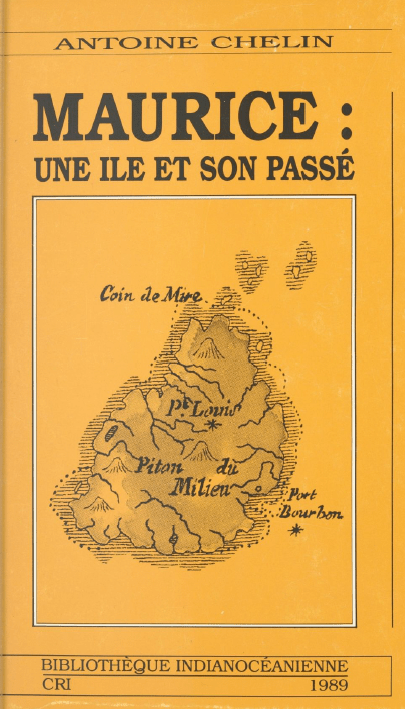
“Maurice : Une Ile et Son Passé” (1989), by Antoine Chelin

I found a digitised copy of this book online: this runs from 1500 to 1750, and chronologically lists many (though of course not all) events in Mauritius’ history.

The author (who wrote in Mauritian newspapers for many years under the anagrammatic byline “HELNIC”) first published this book in 1973, then released a chunky supplement to it in 1982, before finally merging the two into a single larger book in 1989.

Here, we’re specifically interested in shipwrecks (“naufrages“) and hurricanes (“ouragans“) in the period 1740-1750 on Mauritius. In the following, I’ve used Chelin’s numbering system to make it easy to look up individual events in the original book.

298: 11 Jan 1740: hurricane which caused considerable damage in the bay of Port Louis

325a: 13 Dec 1743: violent hurricane which caused considerable damage to the whole island

337: 17-18 Aug 1744: the shipwreck of the Saint-Géran off the Ile d’Ambre, close to Poudre d’Or, subsequently made famous by Bernardin de Saint-Pierre by his fictionalised version of the event in his novel Paul et Virginie. The ship had a cargo of 54000 Spanish piastres plus machinery for a sugar factory that was being built.

354: 10 Dec 1746: return of Mahé de La Bourdonnais from Madras.

361: 21 Jan 1748: hurricane which caused great damage to boats in the harbour of Port Louis – the Brillant, the Renommée, and the Mars were all beached, and three other boats were lost. “The kilns of Isle aux Tonneliers were destroyed, houses in Port Louis were thrown down; Pamplemousses Hospital
was flattened, the wings of the Monplaisir building in Les Pamplemousses lost their roofs, bridges were washed away, shops in Port Sud-Est were knocked down, the newly-built battery at Trou-aux-Biches was flattened by the waves.

377: 7 Nov 1748: “departure for India of part of the squadron under the orders of Capitaine de Kersaint. It is composed of the Arc-en-Ciel, Capitaine de Belle Isle, 54 cannons, crew of 400; the Duc de Cumberland, enseigne Mézidern, 20 cannons, crew of 179; and L’Auguste, enseigne de Saint-Médard, 26 cannons, crew of 130.”

378: 9 Nov 1748: “Departure of the rest of de Kersaint’s squadron, consisting of Alcide, captained by de Kersaint, 64 cannons, crew of 500; Lys, frigate captain Lozier Bouvet, 64 cannons, crew of 476; the Apollon, enseigne de La Porte Barrée, 54 guns, crew of 383; and of the Centaure, ensign de La Butte, 72 guns, crew of 522.”

379a: 26 Nov 1748: arrival of the frigate Cybèle from Pondicherry, announcing the news that the siege of that place by the British had been lifted.

389: 10 Jul 1750: shipwreck of the Sumatra at l’Ile Plate, which had left Port Sud-Est carrying a cargo of wood headed for Pondicherry (14 crew drowned).

A new Bernardin Nageon de l’Estang timeline?

Previously, I had speculated that Andre Bernardin Nageon de l’Estang might have been part of La Bourdonnais’ cobbled-together fleet that sailed to Madras in May 1745. It was certainly true that many Mauritians, rattled by the loss of the Saint-Géran in January 1744, didn’t want to take part: though as a former sailor in the Compagnie des Indes, I suspect Bernardin was unlikely to have been in that group.

In March 1748, (British) Admiral Boscawen arrived at the island with 28 boats en route to Pondicherry, angling for a fight: however, the only French ship he encountered was Capitaine de Kersaint’s Alcide at Port Louis. When Boscawen subsequently arrived off the Coromandel coast in August 1748 in his flagship the Monteran (after a detour to Bourbon in July 1748), his fleet was (according to H. C. M. Austen, p. 21) “the greatest European fleet ever seen in the East“.

Later in 1748, a small French/Mauritian fleet assembled itself under Capitaine de Kersaint. Maybe Bernardin could not say no to joining that small squadron that left Mauritius in November 1848 to try to relieve the siege of Pondicherry. However, they were not to know that the treaty of Aix-la-Chapelle had already been signed on 30th April 1748, making their journey pointless.

And so I can’t help but wonder: might the “treasures saved from the Indus” hidden by Bernardin Nageon de l’Estang have been from a ship wrecked by the huge cyclone that hit Mauritius on 21 January 1748? And might the enlistment Bernardin talks about in his Last Will and Testament have been the (actually unnecessary) squadron under Capitaine de Kersaint that left Mauritius on 7-9 November 1748?

“I’m about to enlist to defend the motherland, and will without much doubt be killed, so am making my will. I give my nephew the reserve officer Jean Marius Nageon de l’Estang the following: a half-lot in La Chaux River district of Grand-Port, île de France, plus my treasures saved from the Indus.”

Note: full letter here

It’s an interesting possible timeline, that (if true) would answer some of the questions I’ve had about timing that have long seemed very slightly off. Even so, the account does remain fairly hypothetical: though on the positive side, it does perhaps suggest some ideas about where to look next.

So… where next for this?

The first thing I’d like to see are contemporary accounts of the hurricane that hit Mauritius on 21 January 1748. The information Chelin reports must (surely) have come from somewhere, but from where? Mauritian newspapers only go back (very incompletely) to 1777 – Le Cernéen and Le Mauricien only started in 1832 and 1833 respectively.

I should perhaps add that the Wikipedia page on tropical storms in the Mascarenes only mentions two from the period 1740-1750 (though note that Grant’s book includes a long section on hurricanes on Bourbon compiled by the Abbé de Caille?):

  • March 8, 1743 – A strong cyclone passed near Mauritius.
  • February 1748 – A strong storm

Note that a letter discussing the 1743 cyclone is quoted in Garnier and Desarthe (2013):

Letter of the governor of the Ile-de-France (Mauritius) of March 8th, 1743:

We had a hurricane on March 8th. The big rashness of the wind lasted only from ten o’clock in the evening till two o’clock at night. Several vessels ran aground in the port because of very high waves which reached the store of the port. The harvest was almost completely destroyed, in particular the corn, the potatoes and the sugar canes. On the other hand, the rice and the manioc were protected. As soon as our port (Port Louis) will be repaired, I shall send to you by boat of the peas of the Cape (South Africa) and the beans which you can distribute in the poorest and to the blacks.

As far as the Jan/Feb 1748 Mauritian hurricane goes, I did find a (fairly miserable) letter from Baron Charles Grant de Vaux dated 10 March 1748 (pp. 293-294):

We have been informed that fifteen ships have been dispatched from the East, laden with provisions for our islands ; but unfortunately the English fell in with them, and, being superior in point of force, have taken them all, except a small vessel, which escaped to make us acquainted with our misfortunes. We live at present in a most wretched state of incertitude, in want of every thing ; and, to complete our misery, afflicted with a continued drought, which has known no interval throughout the year, but from an hurricane that visited us during the last month. It ravaged every thing, and occasioned many fatal accidents. Several persons were killed and wounded during its continuance ; and, to complete our distresses, it was succeeded by a cloud of locusts, which devoured whatever the hurricane had not laid waste. Such is our present situation, &c. &c.

For other sources, I haven’t yet found any journaux de bord covering 1748 (the Achilles’ only goes up to 1747), nor any prize papers, and the Log of Logs starts from 1788, alas. I’ve also asked Professeur Garnier if his researchers found any sources on the 1748 hurricane. Myself, I haven’t yet found anything relevant in gallica.fr, though the chances that something useful is there are surely quite high. The French maritime archives are similarly daunting and huge.

But at least I’m looking for something now. 🙂

In Part 1 and Part 2, I looked at how early British ‘geophys’ technology and Mauritian treasure hunting dreams converged in the 1920s. But once the Liverpool firm of W. Mansfield & Co had been persuaded by the Klondyke Syndicate to jump into the Bernardin Nageon de l’Estang treasure-hunting fire, I think it’s safe to say that just about all outcomes were going to be bad.

So what did happen next? And who exactly was “Captain Russell”, Mansfield’s main man in Mauritius?

The Death of the Dream

From a short article in the The Daily News (4th February 1927, p.10), we can see almost exactly to the day when Mansfield’s expensive treasure-hunting collaboration with the Klondyke Syndicate ended up:

After several unsuccessful attempts to locate what is known as the “Klondyke Treasure” on this island, Captain Russell, of Liverpool, is returning to England.

It is understood that Captain Russell was sent out by a large Liverpool firm for the purpose of prospecting for precious metal. A staff of 50 men and women, under his control, have been engaged for the past 18 months in elaborate excavations. Each successive attempt has ended in failure, and the expedition has finally decided to abandon the treasure hunt.

The last attempt alone is said to have cost £15,000.

But who was he? For several years, I and others have been trying to find out more about Captain Russell: apart from a few brief newspaper articles (such as the Daily News article above), he seemed to have been almost as hard to find as the Klondyke Treasure itself.

Well, that was the situation until this weekend, when my latest attempt to rake keyword phrases through the British Newspaper Archives at long last yielded what seem to be interesting results…

The Lusitania!

In the Linlithgowshire Gazette of 17th May 1935 p.3 (don’t say I don’t spoil you), I found an article discussing a particularly hi-tech sea expedition to locate the wreck of the Lusitania:

An expedition will set out from the Clyde next month to the wreck of the Lusitana [sic] to attempt to retrieve documents and other valuables locked in her strongroom.

Cinema pictures and still photographs of the liner will be taken to show the world how the former pride of the Clyde lies shattered under the waves.

The venture is being organised by the Argonaut Corporation, Ltd., of London and Glasgow.

A ship named the Orphir is now being fitted out in the Beardmore Dockyard at Dalmuir.

The equipment embodies all the latest contributions of modern science and engineering to deep-sea exploration. One of the most valuable units is a flexible metal diving suit, fitted with mechanical hands, which will enable divers to work safely and comfortably in depths hitherto unattainable, with the mobility of the ordinary rubber dress.

Wonderfully, the (actually very fascinating) Coast Monkey website has some pictures of this state-of-the-art diving suit from 1935 being lowered into the water with intrepid diver Jim Jarrett inside, which you really need to see here to appreciate:

The metal dress was tested in Loch Ness by experts, who testified that at a depth of about 450 feet they had the same freedom of movement as was possible at only a few feet down.

With the new dress, divers will be able easily to reach the Lusitania, lying 280 feet deep, and work their way freely into the wreck, if necessary burning a passage through the steel hull with oxy-hydrogen burners.

Locating the Wreck

The article continues:

It is known that the Lusitania lies approximately ten miles off the Old Head of Kinsale, Ireland, and it will be necessary to scour about 15 square miles of the ocean bed to find her.

To eliminate the hit-or-miss element in the search, the organisers of the expedition will divide the area into squares, each of which will be explored in turn until the ship is located or the entire area covered.

A buoy will be anchored in the centre of the square, and measuring with a rangefinder the distance of the ship from the buoy, in conjunction with compass bearings, the invisible sea furrow ploughed by the ship will be accurately traced on a specially made chart. The chart will show the area covered each day, and make it impossible for the navigator to duplicate his tracks.

NOTHING FANTASTIC

Captain Henry Russell, marine superintendent of the expedition company, explained on Monday the method of operation in detail.

Captain Russell emphasised that there was nothing hare-brained or fantastic about the expedition. “I might emphasise that we are not going to make any attempt to refloat the Lusitania – a project which would be absurd,” he said.

“Nor do we expect to find any bullion on board. This is not a treasure-hunt. It is a practical demonstration of what can be done to explore the hitherto unrevealed secrets of the ocean bed with our modern apparatus.

“After the Lusitania we intend to explore other wrecks.”

Now, I can’t yet definitively prove that this Captain Henry Russell setting off to the Lusitania in 1935 with hi-tech sounding gear was the same Captain Russell who had previously gone to Mauritius on behalf of William Mansfield. But… I think it’s overwhelmingly likely.

His “Romantic Quest”

The Motherwell Times of 19th July 1935 (p.8) wasn’t fooled: this trip to the Lusitania was indeed “Captain Henry Russell’s Romantic Quest”:

Captain Henry Bell Russell, commander of the salvage vessel Orphir, which left Dalmuir on Monday afternoon on the first lap of her epic-making expedition, as a result of which it is hoped to raise the treasure of the Lusitania, the great Atlantic liner sunk off the Old Head of Kinsale on May 7, 1915, by a German U-Boat, is a Wishaw man.

His residence is in Coltness Road, Wishaw. Captain Russell has considerable experience of deep-sea diving work in the Persian Gulf as one of the masters employed by the Indo-Burma Petroleum Company, which has released him temporarily to command this unusual expedition.

So we now know that his full name was Henry Bell Russell, and that in 1935 he was living in Coltness Road, Wishaw. What do the archives have to tell us about this no-longer-unnamed man?

About Captain Henry Bell Russell

Thanks to the very useful ScotlandsPeople website, I was able to quickly find that:

  • Henry Bell Russell was born in 1897 (in Govan, ref 646/2 1505)
  • His first wife was Mary Eveline Arthur, they married in 1929 (in Kelvin, ref 644/13 246)
  • Another Henry Bell Russell was born in 1933 (probably Captain Russell’s son?)
  • Henry Bell Russell had a house and a cottage in Cardross in 1940
  • His second wife was Mary Meehan Hamilton, they married in 1946 (Maryhill, ref 644/12/51)
  • Henry Bell Russell died in 1989 (mother’s surname Imrie) aged 91 (Glasgow, ref 605/ 455)

Patrick O’Neil was able to confirm much of this (though via quite different databases):

  • Henry Bell Russell was born 8th October 1897 in Govan
  • His parents were Henry Russell, a commercial traveller born in 1869, and Margaret Russell, born 1871
  • In the 1901 census, he had older sisters Margaret I (Imrie?) born 1896, Marion B (Bell?) born 1894, and Mary Mci (Macintosh?) born 1893.
  • He joined the Navy on 12th December 1916 as a student: he became a quartermaster rating
  • At that time, he was: 5 ft 4½ tall, 33 inch chest, black hair, blue eyes, fresh complexion.
  • His first wife (according to the Shetland Times) was Mary Eveline “Queenie” Arthur, and they married on 2nd September 1929
  • He later formed a metallurgy / chemistry company called United Compositions (Ltd), 108 Douglas Street, Glasgow, with Charles Norman Exley, a chemist of 16 Elie Street, Glasgow.

And, rather nicely, here’s a fetching picture of our fellow as a young man in his pre-Captain days:

I further found that from 1914 to 1916, he was enrolled at The Glasgow School of Art studying Drawing and Painting, leaving his course in December 1916 to sign up for the Navy. His address then was 9 Minerva Street in Glasgow.

Captain Russell’s Mysterious Second Wife

There’s one final scrap to throw to any genealogical wolves whose previous mild interest in Captain Russell hasn’t by now been utterly sated: a series of slightly confused posts from 2011 on GenesReunited by a poster called “Big” (whose account has since expired).

These relate to Captain Russell’s mysterious second wife Mary Meehan Hamilton: I additionally found a record of them travelling on the motor ship (MS) “Patella” from Curacao to New York in March 1947, which one might suspect was part of their honeymoon.

The poster “Big” seemed to think that Mary Meehan Hamilton was born in 1912, married a Mr Adams in 1924 (yes, really), had seven children (sadly some of whom died from diptheria), was with child when marrying Captain Russell, but married him bigamously under the surname “Cunningham” (her second husband’s surname).

Maybe inside all this morass of detail there’s a four-hour Snyder Cut of Captain Russell’s epic life just itching to be made, who knows?

And next…

Will there be a Part 4 to this story? Right now, I’m kind of hoping there won’t… but still, “never say never“, as they say in showbiz, amiright?

In Part 1, we saw the outlines of how technology converged with Mauritian treasure hunting mania in the 1920s. But what was that technology, and how ultimately did it link in with Mauritius?

“Listening for Coal”

The person behind the sounding technology was a Mr W. Mansfield, and the story behind it appeared (very appropriately, it has to be said) in The Liverpool Echo, 12th June 1924, page 7, under the title: “Listening for Coal / How Liverpool Inventor Finds Seams / Treasure-Hunters Agog. / Story of Hoard Buried by Pirates“. Tiresomely long title aside, I think the article bears quoting in full:

An invention by Mr William Mansfield, of W. Mansfield and Co., engineers, of Liverpool, by means of which not only the position, but the actual shape, of metalliferous deposits deep in the ground may be indicated on the surface, has aroused widespread interest, especially in the mining industry, for which it was particularly intended to apply.

This instrument follows the automatic water and oil finders of the same company, which are being used, it is claimed, with 100 per cent. of success in all parts of the world, and which are supplied on the principle of “no full supply, no pay.”

So, what Mansfield was offering was a kind of echo-sounding technology, which he claimed could be used for many types of prospecting & searching.

In seeking for metals or coal deposits, a very simple electrical device is set up on the surface of the ground, sending a curious musical note through the earth, and a couple of assistants – a man and a boy can carry out the tests – can indicate the presence or absence of what they seek by means of sounders.

Wherever the note is clearly heard the ground is sterile so far as metals or coal are concerned, but when the note diminishes greatly or ceases entirely the indications are that they are walking over deposits. By stepping on and off this cone of partial or complete silence and driving pegs they can outline the form and extent of the deposit, and a simple calculation gives the depth.

News of the invention has greatly increased the enthusiasm of those who believe they know, roughly, where treasure lies buried, and Mr. Mansfield has had many calls from such people.

One treasure hunter had the instrument tested on a piece of ground in Cheshire, where a quantity of metal was buried some twelve feet below a ploughed field. Two men who were entirely ignorant of the position of the “treasure” located the place with precision by means of the automatic finder.

The treasurer[sic]-hunter bought the instrument, and he and a party have taken it to the Spanish Main confident that if they don’t find the doubloons they seek it will be because they are not there.

OK so far: but it’s the final section below that’s arguably the most interesting, because it makes a direct link to Mauritius a couple of years before Captain Russell travelled there (on his doomed treasure hunt):

Mr. Mansfield told an “Echo” reporter that it was child’s play to find a chest of metal a few feet down, and he was too busily occupied with the serious work of which the apparatus was capable to accept all the offers he received to join in expeditions for the discovery of hidden gold and silver which might not exist except in the minds of the seekers.

A letter from the magistrate on the island of Mauritius, in the Indian Ocean, is being looked into, however.

This gentleman, Mr. H. E. Desmarais, and a number of influential friends believe there is £30,000,000 worth of treasure buried on the island, representing booty seized by pirates from British and Spanish vessels well over a hundred years ago.

The proposal made to Mr. Mansfield is that he should locate the treasure for them, and receive a quarter of the find.

In view of the influential backing, Mr. Mansfield is making inquiries. As he points out, if nothing is found, a one-fourth share would not go far to meet his expenses in going out to Mauritius!

By the way, who was H. E. Desmarais?

The above article refers to H. E. Desmarais as a “magistrate”: and indeed Google helpfully supplies links where H. E. (Henri Eugène) Desmarais appears in the Colonial listings as Moka Magistrate for Mauritius (with a salary of 7,000 rupees in the 1890s), having been first appointed there on 1st August 1884.

A family tree on MyHeritage says that Desmarais was born 11 March 1843, and died 22 August 1928. He married Wilhelmina Sophia Henriette Ferdinandine Dancker on 2nd September 1868 in Melbourne: they had ten children. He was the third son of Jean Baptiste Evenor Desmarais, of Port Louis, Mauritius, who himself had been an attorney-at-law. His own law training was as a student of the Middle Temple (18th August 1863): he was called to the bar 30th April 1866.

There is a (paywalled) mention in Alfred North-Coombes’ (1971) book “The Island of Rodrigues” that suggests one of Desmarais’ early appointments was as Rodrigues’ Police Magistrate in 1876.

And finally: in the 1922 Blue Book of the Colony of Mauritius, H. E. Desmarais was listed as receiving (as a retired District Magistrate) a 4,216 rupee pension (79%) since 1913, having then retired “of Old Age”.

All in all, it seems entirely reasonable that Desmarais would have been a member of the Klondyke Syndicate. Incidentally, the mention of his “influential friends” was without doubt a heavy-handed (and deliberate) reference to the “Par nos amis influents, fait toi envoyer dans la Mer des Indes et rends-toi à l’Isle de France, à l’endroit indiqué par mon testament” sentence that appears in letter BN2.

W. Mansfield’s Company & Technology

The 1914 “Who’s Who In Business” includes the following description of W. Mansfield’s company:

Mansfield, W., and Co. Consulting Engineers and Well Boring Engineers, Creewood Buildings, Brunswick Street, Liverpool. Hours of Business: 9.30 a.m. to 6 p.m. Established in 1900 by W. Mansfield, the present principal. Premises: Extensive. Branches: Yenangyat, Promo and Eastern Boronga. Business: Consulting Engineers for many important irrigation projects. Pioneers of Long Staple Cotton Growing in Burma. Owners of Oil and Mineral properties; Well Boring Engineers. Patent: Mansfield’s Automatic Water and Oil Finders. Connection: United Kingdom, Foreign and Colonial. Telephone: No. 1392 Central, Liverpool. Telegraphic Address: ” Mantles, Liverpool.” Codes A B C, Engineering and Private. Bankers: National Provincial Bank of England, Ltd. Mr. W. Mansfield is a member of several Engineering and other Societies. He is interested in Educational questions and has travelled throughout Europe, Asia, and Africa.

From the Grace’s Guide entry on the company, you can see that it was selling its water finder technology by at least 1911. Mansfield’s company later hit the papers in 1931 (10th October, Liverpool Echo, p.13) when a 30-year-old employee sadly got hit on the head and died: and it was still advertising in 1934 (18th July, Liverpool Echo, p.13).

So, what did its metal-finding device look like? Luckily, we don’t have to rely on mere verbal descriptions of Mansfield’s echo-sounding technology, because there are a number of advertisements and articles that contain actual pictures (even if the endorsements that go with them do sound somewhat made-up, it should be added). Here’s a W. Mansfield advert from Chambers’s Journal that sits above an advert for a Dulcitone (which is why the Royal College of Music has a scan of the page on its website):

Coming up next…

In Part 3, I hope to tell a little of the story behind Captain Russell, who led Mansfield’s treasure hunting expedition to Mauritius…

I’ve had some interesting emails recently from Patrick O’Neil, who I’m very pleased to report has picked up my long-dropped baton on Mauritian treasure hunting in the period between the two world wars. By uncovering a number of sources I was unaware of (and with only minor assists from me), Patrick has started to reconstruct a side of this story that was previously only hinted at.

“Treasure Hunting in Mauritius”

An article titled “Treasure Hunting in Mauritius” by James Hornell in the 9th April 1932 edition of “The Sphere” (p.57) vividly sets the scene. The famous Mauritian treasure is none other than Surcouf’s, its author asserts, hidden in a cave “on a lonely stretch of coast”, but never retrieved:

A few years ago a plan giving clues to the position of the cave was brought to Mauritius – once a death-bed legacy ! A syndicate [the “Klondyke Syndicate”] of well-known local people was formed to follow up the clues. It was easy enough to identify the narrow gully or gorge in the cliffs up which Surcouf had carried his loot ; two of the stones marked on the plan were located, one with what seemed to have a letter or figure roughly carved upon it. Hope ran high, but now a check was registered ; no trace of a cave could be found ; it was thought that a landslide had taken place covering the mouth. Trial cuts were made here and there but no progress was made, and when the money subscribed ran out, the work ceased.

Hornell goes on to tell us how the search for the treasure then went ‘hi-tech’:

At a later date negotiations were opened with an engineering firm in England, and under agreement of equal shares to each party, an electrical divining instrument, designed to locate metal, was brought into use. Unfortunately the only spot where the pointer became agitated was over a surface of solid rock. From this it was inferred that the landslip had covered the entrance to the cave to a great depth, and that the spot indicated was above the end where the treasure lay. Weary weeks passed in cutting a way down through dense basalt rock of extreme hardness. Ten feet down they went without success ; then to twenty and on to thirty ; at about thirty-five they struck earth, and this raised their hopes to fever pitch. Immediate success was assured – the earth-filled cave was reached at last ! The island authorities were notified and a detachment of armed police went excitedly down to the gully to afford protection, So sure was the engineer of success that a motor lorry was requisitioned to convey the gold and jewels to the bank.

What happened next? Sadly, the dismal punchline is all too easy to predict:

Alas ! Hard rock soon reappeared and the electric indicator still encouraged further effort downwards in the same spot. Two months later when the depth of the shaft had reached over fifty feet I was invited by the engineer to visit the place. I could but admire his tenacity of purpose in face of prolonged disappointment and his patience in laboriously cutting a shaft through virgin rock with chisel and crowbar, afraid as he was to use explosives.

Incidentally, if you’re wondering who the author of this piece was, I’m pretty sure he was the “internationally well known fish expert and colonial adviser based in India” (and former Director of Fisheries in Madras) James Hornell F.L.S. F.R.A.I. (1865-1949), who wrote numerous books on fish, fishing, fishermen, and fishing boats all the way from Britain to Oceania. And did I mention he was interested in fish?

Anyway, even though this helps us glimpse the big picture, we are still left with many questions. For example: where was this site?

“A spot known as Klondyke”

Helpfully, a column in The Daily News of 13th April 1926 reporting on this story describes the location (albeit somewhat inexactly):

The scene of the search is a spot known as Klondyke, on the west coast of Mauritius, in the Black River district, and the treasure, which has come to be spoken of as the Klondyke treasure, is believed to have been secreted there between 1780 and 1800 by the Chevalier de Nageon, a noted privateer.

Unlike the version of the article that was reproduced in the Brisbane Telegraph (which I typed up here), this includes a rough-and-ready map, with a piratical “X” to mark the (approximate) spot:

The article continues:

A number of attempts have been made, at intervals since 1880, to find the treasure, and excavations were made in accordance with instructions sent to a Mauritian from one of his relatives in Brittany.

Then the Chevalier de Nageon’s own plan was said to have been found, and a company was formed to begin regular diggings.

Some stonework and other clues tallying with the plan were brought to light from time to time, but nothing else happened, and the shares of the Klondyke Company – held by about a score of persons – became temporarily worthless.

But by the end of last December these shares were selling at 5,000 rupees (about £375) each. This was because Captain Russell had come across new indications which gave rise to the highest hopes.

(Incidentally, has anyone ever actually seen a physical share in the Klondyke Company? I’m sure I’m not alone in wanting to have one framed on my wall.)

There was also a mention at the article’s end that “the native diggers, as I hear today, are feverishly excited concerning yet another treasure, supposed to have been hidden by the same Chevalier de Nageon at Pointe Vacoa, Grand Port“. As you’d of course expect, “(f)abulous figures are mentioned in this latest story”: the Mauritian treasure hunting ‘virus’ is one that constantly mutates…

To be continued…

In Part 2, I’ll go on to look a little more closely at the Liverpool engineering company and their strange machine…

Here’s an official document from 1760 from the Mauritian Archives relating to the Nageon de l’Estang family property:

(Click on the image to get a higher resolution JPEG.)

And here’s a transcription very largely provided by Ruby Novacna, with additional parallel transcriptions from Anthony Lallaizon and Thomas below – thanks very much to all three of you for this excellent help!

Rather than modernise the text, my preference (as per Ruby’s excellent work) is to try to stay close to the original spelling, though anyone wanting to grasp what it means might prefer Anthony’s and Thomas’ versions in the comments below:

1. Le conseil Superieur de l’Isle de France a tous Presents et
2. aVenir Salut. Scavoir faisons qu’en consequence des Ordres de
3. la compagnie inseréé dans la deliberation du deux Janvier M
4. Sept cent cinquante trois [i.e. 2nd Jan 1753] et de ladite Deliberation Nous Avons au Nom
5. De Messieurs les Sindics et Directeurs De la Compagnie Des Indes
6. Concedé et Delaissé Concedons et Delaissons Des maintenant et p[our] toujours
7. Par ces presentes au sieur André Nagëon De l’Etang fils Du sieur
8. Bernardin Nagëon Son père De son vivant officier Des Vaisseaux
9. De Côte p[our] la Compagnie ledit André Nagëon Demeurant chez M[a]d[am]e
10. Sa Mere, En ce port et Paroisse Louis a ce present et acceptant P[our] Luy
11. Ces hoirs et ayant cause la propriété D’un terrain De treize toises
12. Deux Pied(s) Delarge Sur Vingt Six toises quatre pied(s) De proffondeur
13. Scitué sur le Rempart De la grande Montagne n[uméro]te 130. Borné D’un
14. Coté par une rue qui conduit alad[i]te montagne Dautre Coté Par…
15. D’un bord un autrerue qui conduit Dans l’Enfoncement et d’autre bout par
(16. Une rue Entredeux)
16. Le Sieur (?)
17. Le tous suivant le plan corigé par M Magon (?) Directeur et Commd[an]t gen[er]al
18. Led[i]t terrain accordéé au S[ieur] Nageon fils par Ordonnance Du Conseil Du
19. Sept may Mil sept cent Soixante [7 May 1760] Pour Par led[i]t Nageon fils Ses enfans
20. Hoirs, ou heritiers meme ceux D’iciluy ayant cause jouir faire et Disposer
21. Dudis terrain comme la chose luy appartenant en toute propriété roturière
22. Et néant moins reconnaitre Messieurs De la Compagnie Des Indes comme
23. Seuls Seigneurs Directs, Suzerains Hauts moyens et Bas justiciers et p[our] ce
24. est sujet atous droits de justice et Banalité quils jugerons a propos D’Etablir
25. Sera tenu ledis Sieur D’Enclore et faire Batir sur ledit terrain de faire
26. Couvrir les Batiments qu’il y fera construire En planches, Bardeaux ou
27. Arg[?] , aux termes presents par les Reglements, s’oblige de payer par
28. annéé sur les ordres et dans les tems qui seront prescrits par le Conseil
29. Douze deniers De premier Cens reputé cens commune et imprescriptible
30. Tant p[our] le fond que pour laquotité lequel Emportera lod(s) et ventes
31. S’aizinnes [saisines] et amendes, au Désir de la coutume de Paris comme aussy
32. D’executer Exactement toutes les Ordonnances et reglements faits et a faire
33. Par la suite par la compag[ni]e ou le Conseil de passer au domaine de la
34. Compag[ni]e. Declaration et reconnaissance dudit terrain et des droits
35. Cy dessus Stipuler le tout a peine de Nullité de la presente Concession De
36. Reunion au domaine Dudit Emplacement Sur le Simple Requisition du
37. Procureur General du Roy Sans estre par la compag[ni]e tenu Daucunes
38. Indemnité. Ny formalité de justice Ny Sans que ladite peine Ny rien
39. Du contenu en la presente Concession Puisse estre reputé comminatoire mais
40. De rigueur étant la condition precise du don gratuit que la compag[ni]e
41. En fait et p(9) que ces presentes ayant leur forces et valeur ou marges
42. D’Expedition d’icelle sera apposéé le sceau de la compagnie des Indes
43. Donné au Port Louis de l’Isle de France le dix de may mil sept cent soix[an]te [i.e. 20 May 1760]
44. Et a Signé
45. Nageondeleteang
46. ? Lejuge ?
47. ?

Oh, and here’s a close-up of the signature at the bottom left, which I read as “Nageondeléteang”, yet another variant spelling to add to the list *sigh*:

In my last Cipher Mysteries post, I floated the idea that when Bernardin Nageon de l’Estang famously wrote that…

j’ai naufragé dans une crique près des Vaquois

… he may have been referring not to the town or inland area called Vacoas, but rather to Pointe de Vacoas on Mauritius’ South-Eastern coast, which was close to the half plot of land he owned. According to his Will (BN1), what Bernardin did immediately after being “shipwrecked in a creek” was:

j’ai remonté une rivière et déposé dans un caveau
les richesses de l'Indus

So: might there be a cave next to a creek not far from Pointe de Vacoas? Generations of Mauritian treasure hunters must surely have put the same two and two together to get the same bejewelled four, right?

But perhaps more importantly, you might be asking what on earth this post has to do with three hundred dead dodos? Has Cipher Mysteries been taken over, as my son asked, by some kind of “ARK: Survival Evolved” meme?

Photo by BazzaDaRambler – Oxford University Museum of Natural History

No, this post is genuinely about treasure and dodos. Really. Read on.

The Creek

Having looked at a fair few historical maps of Mauritius, it seems to my eyes that there was only ever one winding little creek near Pointe de Vacoas. Rather than starting from beside the Point itself (as per the cadastral map I mentioned in the last post)…

…the creek actually starts a little to the side, though it does then indeed kick sideways across towards the Mare du Tabac, which became the Union Vale Sugar Estate:

Source: Mauritius Chamber of Agriculture

In this 1880 map, you can see “Pte Vacoa” in the bottom right leading round to a small river (the “Ruis[seau] des Marres”) that winds its way inland, before finishing up by the Union Vale railway station (at centre left).

Union Vale, 1880 map of Mauritius

OK, while I’m not saying that Ruisseau des Marres is ‘definitely’ the stream / creek that Bernardin was referring to, what I am saying is that it seems (to my eyes) to be a very strong candidate indeed. For if you don’t look there, where else would you to go looking first, hmmm?

Going over the map carefully, you should also be able to see the area around the Ruisseau des Marres is called “LES MARRES”. There are also a couple of odd-looking features on the map labelled as “Mare …”, the right of which is labelled as “Mare aux [something] or Dodo“. Unsurprisingly, we’ll be returning to that location before very long…

The Cave

I first started thinking about Mauritian lava tubes back in 2016, and have never really stopped. This is because Bernardin’s second letter BN2) runs:

l'entrée d'une caverne jadis formé par un bras
de rivière passant sous la falaise et bouchée
par les corsaires pour y mettre leur trésor et
qui est le caveau désigné par mon testament

…which I think sounds exactly like a description of a lava tube.

Here’s a rather nice 1820s drawing by de Sainson of a Mauritian lava tube in the Grande Riviere quartier (not too far away) that I previously mentioned in a separate post:

Though the lava tube or lava blister we’re looking for must surely have been more modestly sized than this epic specimen, it’s the same basic idea.

Mare Aux Songes

In a rather charming 2007 New Yorker article called “Digging For Dodos“, we meet a gaggle of dodo experts and enthusiasts, all inspired by the Mare Aux Songes – a (formerly) boggy pond in the South-East of Mauritius. This site was discovered in 1865 by local teacher George Clarke, after his thirty year search for dodo bones.

In fact, the Mare Aux Songes ended up yielding far more dodo bones (from more than 300 separate dodo skeletons!) than everywhere else combined. Hence even the dodo skeleton at Oxford University Museum of Natural History (yes, the photo at the top of the post) was from the Mare Aux Songes.

In response to a malaria epidemic a few years later, British engineers covered the whole boggy area with concrete to prevent mosquitoes breeding: the Mare Aux Songes then spent most of a century out of reach.

The experts (in the New Yorker article) had formed a group called the 2006 Mauritius Dodo Expedition, with the idea of revisiting the Mare Aux Songes with a more modern scientific approach, to find more about dodos. Specifically, they wondered whether they might find multiple historical layers of dodo remains. But what they actually found was that all the dodo bone fragments seem to have come from a relatively short period around 4000 years ago.

What exactly had happened? The report outlines the group’s conclusions:

The geomorphology of the rock valley, in particular being bounded by steep cliffs, suggests collapse of a pre-existing cavity in the subsurface. In volcanic settings rock valleys generally evolve from the collapse of lava tunnels (e.g. Peterson et al., 1994), and these systems are common in (SW) Mauritius (Middleton, 1995; Saddul, 2002; Janoo, 2005), suggesting that the MAS rock valley was created in a similar way. Therefore at some point after 120 ka, large-scale roof collapse led to the formation of a dry valley at MAS (Fig. 4A).

“Mid-Holocene vertebrate bone Concentration-Lagerstatte on oceanic island
Mauritius provides a window into the ecosystem of the dodo (Raphus cucullatus)”

So, the basic narrative they reconstructed was this:

  • the Mare Aux Songes had started out as a lava blister (i.e. a void inside the volcanic basalt) with a diameter of ten or more meters;
  • the lava blister’s roof had weathered and collapsed, leaving behind an exposed hemispheric ‘bowl’;
  • there had been a long dry period, perhaps across a couple of centuries;
  • during that dry period, a large number of animals (mainly turtles, but a few dodos too) had found themselves trapped inside the steep-walled bowl; and
  • this was where, unable to climb back up its steep walls to escape, the three hundred dodos died.

And you will surely be unsurprised to find that the Mare Aux Songes mentioned on the map above is (or was) the boggy pond that formed in a roofless lava blister about 1km NNW of Pointe de Vacoas (as per the 1880 map).

Local Ponds and Caves in 1838

The best historical source on the geography of the local area I have found so far is the (1838) book “Statistique de l’Ile Maurice et ses dépendances” by M. le Baron d’Unienville.

Helpfully, the Baron lists the ponds (“mares”) of most interest in this quartier (my loose translation) [pp.139-140]:

The Mare la Violette, on Lahausse's land, yields a lot
of water, nevertheless sometimes drying up, but only
very rarely; its waters drain into le Bouchon.

The Mares du Tabac spring from between the Toussaint,
Avice and Buttié plots; they provide eels [anguilles],
shrimps [chevrettes], and water snails [corbeaux]; they
drain out into the Cul du Chaland, towards le Bouchon.

The Anse-Jonchais, Bambous and Albert ponds sometimes
dry up, but all provide very good water.

On M. Fenonillot's land, there is a natural pond three
to four hundred fathoms long by one hundred wide, becoming
up to 25 feet deep in the rainy season, with water springing
from the earth. This pond dries up in the dry season.

Interestingly, the Baron didn’t even consider the Mare Aux Songes to be worth reporting on, presumably because it was so marshy and boggy that you couldn’t get any useful water from it.

But more interestingly, he goes immediately on to discuss the caverns of the quartier (again, please forgive my loose translation) [pp.140-141]:

This district is very cavernous in places, especially towards
the coast going round from Chasur to the point.

In several parts of the Mares-du-Tabac area, the ground
resonates hollowly under the footsteps of men. The artificial
excavations present there the certainty of a great upheaval
formerly caused by underground fires, since in addition to
volcanic stones whose soil is covered, the layers of earth
are firstly topsoil, then tuff [a light, porous rock formed
of volcanic ash], then earth again in unequal layers always
interspersed with volcanic stones.

The Pointe du Souffleur offers a rather singular phenomenon,
also found in other regions; the water pushing violently into
the cavities of this point, emerges in a jet of water rising
to a rather great height through a hole two to three inches
in diameter, with the compressed air producing a noise similar
to that of a strong forge bellows.

There are several excavations in this area that are believed
to go through to the sea, such as the Fanchon hole and the
Maignan hole. The first is located on the Chemin du Port, home
of Sieur Leroux, and the second on the Maignan land. Tests
have been carried out to map the underground routes and
interconnections between these holes; but those tests were
unsatisfactory, because the lack of air causes lights to
be extinguished beyond a certain distance.

Sieur Charroux, among others, spent twenty-four hours lost in
the labyrinths of these caves, and considered himself very
fortunate to find the opening through which he had entered
and which may be twenty feet deep.

All in all, I think there is ample reason to believe that Bernardin Nageon de l’Estang’s description of (what sounds to me like) a lava blister or lava tube beneath a cliff is entirely consistent with the geology of the area around Mare la Violette.

It may sound overly romantic, but it seems certain to me that there are still as yet unmapped voids under the ground; and it might well be that one of these once had a concealed entrance. Perhaps the notion that pirates used these voids is just a campfire story (it wouldn’t be the first or the last): but nonetheless, voids there were.

The Cave Nobody Found

The local landscape circa even 1900 was very different on the surface to how it was circa 1750. Much of the area had been razed for growing sugar cane; estates and railways had been built; marshes had been filled and capped in response to the Epidemics of Mauritius; and so forth.

And so by the time of the great explosion of interest in Mauritian treasure hunting in the early 20th century, the area along the Ruisseau des Mares was probably close to unrecognizable. Not that this probably did anything to stop the grimly determined treasure hunters of the era with their fake maps, rumours, hunches, dynamite and shovels. Who knows what features they blew up in their hunger for buried gold?

Now a large part of the same general zone is being redeveloped by Omnicane – a company formed from Mon Trésor & Mon Désert sugar companies, among others – into the Mon Trésor Airport City project. So perhaps the cave we’re looking for has already been unknowingly flattened and redeveloped ten times over, who can tell?

If (and I happily admit that it’s a big if) Bernardin Nageon de l’Estang’s treasure is still in the cave he left it in nearly three hundred years ago, then the way forward is surely through GPR (ground penetrating radar), tracking along the land beside the eastern bank of the Ruisseau des Mares. But it is (and probably will always be) a needle-shaped void in a lava haystack.

Still, even though it took George Clarke thirty years to find his cache of three hundred dead dodos, who would now say that his search wasn’t worth it? And surely that’s how Mauritian treasure hunters feel (more or less), right?

Even so, rather than hiring a load of GPR equipment, I have to point out that you would (thanks to the French treasure hunting laws that Mauritius inherited) probably be better off instead walking up and down beside that river bank until you fell down a hole into a long lost treasure cave.

As they say in the theatre, break a leg. 😉

Finishing With A Song

It’s rare that you can write a blog post that covers an unsolved historical mystery and yet brings in so many nice historical angles along the way: rarer still that you can do all that and end on a song.

So here’s my cousin Phil Alexander (AKA “Philfy Phil”, recorded at The Goat, St Albans in 2010) with “Dido Dies”, one of his… errrm… cleaner parody songs. The first verse and chorus are about dead dodos, and you already know the tune, so feel free to sing along, you know you want to:

The final dodo walked the earth four hundred years ago
No more flapping wings and croaking; the dodo, yes, has croaked
He’s in the doodoo
He lies extinct
No more delicious in Mauritius
Or at least that’s what I thinkt

Then Salvador Dali died in 1989
With the oddest of moustaches
Like his anti-artist predecessor, Dada
Painting stuff
Did he look back and then realize he’d painted quite enough?
And well… let’s face it, most of it was guff

Dada died, Dali died, da dodo died
D’oh, da dodo died