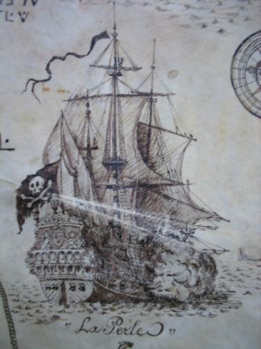
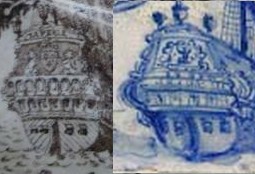
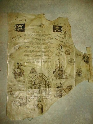
The second “La Buse” cryptogram is a funny old thing: Emmanuel Mezino swears to its authenticity, but I’m really not as convinced as he is – given that a number of key elements (such as the cryptography, the dates, the drawing style, etc) seem jarringly incongruous to my eyes, there seems plenty of good reasons to infer that it is (at best) a later copy and/or an assemblage of earlier pieces, or (at worst) a modern fake.
Here’s Yannick Benaben’s image of it, the earliest that I’ve found on the web:-
And then there’s the cryptogram’s map to consider. Even though La Buse (Olivier Levasseur) ended his piratical career in the Indian Ocean, he seems to have begun it in the Caribbean, so it perhaps shouldn’t be at all surprising that this cryptogram should contain a very high-level map of the Florida / Caribbean area.
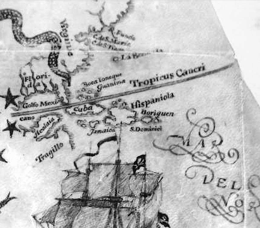
Many names on the map can be identified without difficulty:
* Florida – though because this area became ‘La Louisiane’ (named after Louis XIV of France, of which it was a colony) in 1682, it would seem that this map predates (or appears to predate) 1682.
* Virginie (= “Virginia”)
* Golfo Mexicano (= “Gulf of Mexico”)
* Tragillo (= “Trujillo”)
* Jamaica
* Cuba
* Tropicus Cancri (= “Tropic of Cancer”)
* Hispaniola – it looks to me as though the island of Hispaniola has been miscopied into two halves.
* S. Dominici (= “Santo Domingo”, Hispaniola’s capital city founded by Columbus’ brother Bartholemew in 1496, and also another name for Hispaniola).
* La Bermuda (= “Bermuda”, although on the map this is positioned way too close to the coast)
Curiously, the map has a snake design that wiggles – coincidentally or not, I can’t say – roughly up the path of the Mississippi. It’s far from historically obvious that the Mississippi River was only discovered (by Louis Jolliet and Jacques Marquette, says Wikipedia) in 1673: and hence it is tempting to suspect that this snake design was added simply to cover up a cartographic slip-up by a later forger or hoaxer (i.e. adding the 1673+ Mississippi River to a map supposed to be linked to La Buse, who died in 1730). But that’s just my speculation, please don’t read too much into it. 🙂
The other map labels, though, are slightly less straightforward.
* Boriquen – this is clearly Boriken, the original Taino Indian name for Puerto Rico (although Columbus called it “San Juan Bautista”, i.e. St John the Baptist Island, which is presumably why the capital is called San Juan, and why the island’s motto is “Joannes est nomen eius”).
* Guanima was the original (pre-1520) name of the Bay of Marantzas on the north coast of Cuba, while “Guanahani” was the Taino Indian name for the first island to which Columbus came (the controversy over which island that actually was continues to the present day). And so it seems likely to me that the island on this map marked as “Guanima” was intended to be “Guanahani”, but got mangled in the copying.
* Boca Ioneque – I have no idea what this is. It’s next to “Guanima” and looks as though it is attached to an island, but I’m not sure if that’s helpful or not. All suggestions welcome!
* “Acalaia” / “Alcaldia” (town hall?), apparently on the Yucatan peninsula – though I did manage to work out what this (miscopied and mangled) label was late last year from some 16th century maps, I now cannot find my careful notes on it at all, bah. 🙁
* R. Fuado – I have no idea what this is.
* C. de S. Marie – I have no idea what this is either.
* C. de S ???? – I can’t even read this, let alone guess what it is.
My Thoughts
This map is hugely odd. Not just the mix of languages (Spanish, French, Latin) or the miscopied labels (Guanima, Tragillo) or the suspicious snake tail (covering the Mississippi?) or the miscopied geography (Hispaniola), but the whole thing seems jarring to me. Manu may be convinced, but to my eyes this is all over the place.
But what do you think?