The debate concerning the authenticity of Beinecke MS 350A – AKA the Vinland Map – has raged for over half a century. Is it for real or is it early modern Maybelline?
Vinland Map Ink
Despite the numerous technical analyses that have been carried out on the Vinland Map, almost the only fact everyone agrees on is the physical age of its paper: it has been carbon dated to the first half of the 15th century, which is nicely consistent with its Briquet Tete de Boeuf (15056) watermark.
That’s the support medium – but what about the rest? The major thing pointing towards inauthenticity elsewhere is (courtesy of Walter McCrone) the analytical demonstration that the ink used in the Vinland Map is not a conventional iron gall ink, but appears to contain a particular form of anatase (titanium oxide) that was first chemically synthesized only in the 1920s. And so, McCrone’s base argument from 1974 runs, it doesn’t matter how old the paper itself is, because the ink on top of it simply cannot be genuinely fifteenth century.
Even so, people continue to try to defend the Vinland Map’s authenticity, by suggesting ingenious mechanisms by which the anatase might have been deposited in the 20th Century: Jim Enterline, for example, plausibly proposed in 2002 that anatase might somehow have been added to a genuinely old map as part of an attempt to clean it.
But when McCrone looked again at the map in 1991, he extended his claim somewhat further into the construction details. Specifically, he claimed that the lines that made up the map were – to make them more closely resemble old iron gall ink, but without actually being old iron gall ink – drawn in two distinct passes:
(1) a first yellow ink pass using a slightly wider nib
(2) a second dark ink pass in a narrower nib, immediately on top of (and steered down the middle of) the lines put down in the first pass.
If this is correct, the Vinland Map is not just a mere fake: rather, it is a painstakingly-executed two-pass modern simulacrum of an old manuscript.
The ‘smokingest’ smoking gun in all of this would seem to have been discovered by Kenneth M. Towe: when he examined the Vinland Map at the Beinecke, he noticed that the two lines diverged significantly in the English west coast.
Now, I’ve personally never seen a colour close-up of this specific section to test out Towe’s argument with my own eyes, but I’d really like to. Has anyone got a copy of this?
Whodunnit?
Even so, the twin issues of who it was that constructed such a thing and for what reason both remain resolutely unresolved. Kirsten Seaver’s 2004 book “Maps, Myths, and Men” tried to pin the tail on a peculiarly unsatifying Jesuit cartomanic donkey, Father Josef Fischer. However, her account failed to convince me that Fischer would have wanted to create a fake Vinland Map of the kind we see for any reason, let alone for the reasons that Seaver speculatively proposes.
So even if the Vinland Map does prove to be a fake (and the presence of modern anatase and the apparent two-pass drawing when taken together do make it seem so), we still have no idea by whom it was made, or where, or indeed when (other than post-1920 or so).
Seaver is convinced she has got the right man; but her argument only really presents a possible candidate, and doesn’t go as far as actually explaining much of what we see or what happened. Perhaps she will uncover something more substantial soon, at which point we’ll all have to revise our views: we shall see.
A Surprise Entrant
In 2013, the modern history of the Vinland Map took an unexpected turn when an amateur Scottish historian called John Paul Floyd announced (courtesy of the Daily Mail, The Sunday Times and doubtless elsewhere) that he had uncovered – thanks to Google searches – an entirely new angle on it.
Floyd believes that the document the Vinland Map appears to have been bound with – The Tartar Relation – was put on display in Madrid in 1892 at an exhibition celebrating the 400th anniversary of Columbus’ Atlantic crossing. And at that time there was no map bound with it (because the page count listed at the time would be wrong). He also found a reference to the same manuscript from 1926 when it was examined by Cristóbal Pérez Pastor (also no mention of a map at all).
Manuscripts for the 1892 exhibition were loaned from the collection of the Cathedral Church of Zaragoza, the contents of which were ransacked in the early 1950s and fenced through crooked book dealers such as Enzo Ferrajoli (who was convicted for this).
And Enzo Ferrajoli was the same rare book dealer who ultimately first sold the Vinland Map in 1957. Ouch!
It’s a pretty compelling chain or reasoning, because for once it offers actual evidence of absence 🙂 rather than speculatory absence of evidence. Of course, it doesn’t yet answer the question of who faked the map or why: but perhaps Floyd (who has been hard at work grinding out his book ever since) has found some additional evidence there too. We shall see, hopefully this year.
Nicely, I found a post on soc.history.medieval by David B that foregrounds Floyd’s evidence:-
The 1892-3 Madrid Exhibition Catalogue
“Catalogo General” of the 1892-3 Exposición Historico-Europea.
Room X:
“53. – Vincentius bellvacensis. Speculum naturale, doctrinale, morale, historiale.
El presente volumen contiene, de esta célebre enciclopedia de Vicente de Beauvais, solamente los libros 21 á 24 de la tercera parte del Speculum historiale.
Al fin se ha añadido un tratadito intitulado Historia Tartarorum dedicado por el autor Fr. C. de Bridia, al R.P. Fr. Bogardio, ministro de los franciscanos en Boemia y Polonia.
Manuscrito, á dos columnas, letra del siglo xv, las cubiertas de cada cuaderno en vitela y lo demás en papel, los epigrafes en tinta roja, el lugar de las iniciales en blanco. Consta de 251 hojas.
La Historia Tartarorum, acaba de esta manera: actum ab incarnatione domini MCCXLVII, tertio kalendas augusti.
Folio, encuadernado en tabla forrada de cuero labrado.”
About which David B comments:
Note that the above gives the number of leaves as 251, which would be almost the same as the total number of leaves with writing on in the two now-separated texts at Yale. It’s one leaf too few if you include the Vinland Map in the current count, but one leaf too many if you exclude the Map, suggesting that the now-missing first written leaf of book 21 of the “Speculum” may have been present in 1892.
Cristóbal Pérez Pastor
“Noticias y Documentos relativos a la Historia y Literatura Espanolas recogidos por D. C. Perez Pastor”:
“Speculum historiae (segunda y tercera parte). Historia tartarum.
Manuscrito, letra del siglo xv, a dos columnas, los epigrafes en tinta roja; cada cuaderno tiene la primera y última hojas en pergamino y las deniz en papel.
Al final lleva la fecha: “Actum ab incarnatione Domim M.CC.XL.VII. tertio Kalendas Augusti”; folio, encuadernado en tabla forrada de piel, con adornos de la época.
Del Speculum hist contiene los libros xxj a xxiv, que dan remate a la parte tercera de la obra.
El Codice comienza con el imperio de Teodosio el joven, y acaba en el segundo reinado de la Emperatriz Irene.
Sigue la Historia de los Tartaros, escrita por Fray C. de Bridia, fransiscano, y va dirigida a Fray Bogixdao, ministro de los franciscanos en Bohemia y Polonia, y se termina con la fecha del 30 de Julio de 1247.”
You have the Vinland map correct. You do not address the loyalty Yale owes to Paul Mellon.
Nick & (so far, xplor):
I’m probably not adding any new stuff to your discussion; but my “Hammond’s Historical Atlas”. page H-5, shows the Roman Empire at its greatest extent (about 117 a.d.): Great Britain (in pink) and nearby Hibernia (white) being Germanic/Scandinavian (not yet part of the Roman Empire).
So, whether any of this (my) discussion is relevant or helpful to validating the so-called Vinland Map or not, please remove me from the tenterhooks of ‘curiousity’: (Curiousity killed the cat; satisfaction brought it back.)
Big smile: 😉
Greg Hodgins told me at the Frascati conference that titanium oxide is quite common in nature and he thought there was nothing suspect about the ink on the Vinland Map.
(By the way, does anybody remember him talking about some map showing the Bering Strait 300 years before Bering, and if so what map was it?)
The worm holes indicate the map was taken from a fly leaf. A common practice of forgers. It dates the paper to the right time period.
My ‘Hammond’s Historical Atlas’ (page H-12) shows the northern-most kingdoms of Norway and Sweden — and Finns. A dotted line across several continents and through to the Baltic Sea and Kingdoms of Norway and Sweden. The map is labeled (by Hammond’s) as “Europe and the Byzantine Empire About 1000”. The dotted line is indicating the route of the “Varangians”.
My edition of “Collins Past Worlds Atlas of Archaeology” has ‘boxed’ the area of “Scandinavia” for further discussion of the Saami culture: Norway, Sweden, Lappland, and Finland. Archaelogical studies go back as for as 3,000 bc. Fascinating! (My spelling, herein, is as appears in the atlas.)
😉
Except for the word for/far !
Still beady-eyed as ever 😉
Philip: in the sixteenth century the ‘Strait of Anian’ was thought to divide the north-west coast of America and the north-east coast of Asia. Although some European cartographers placed it as far south as California, most seem to have located it roughly where the Bering Strait is now known to be, and some appear to have hoped it might have formed the other end of the North-West Passage. I believe it is still found on some early eighteenth-century maps.
I don’t know whether maps from other cultures showed what is now called the Bering Strait at an earlier date.
I revisited my “Hammonds” (page H-19) — at top of map (15 degrees W) there is discussion of Iceland:
“The Norsemen settled in Iceland in 874 a,d, and Greenland in 985. Between 1000 and 1347 they visited Labrador, Newfoundland, Nova Scotia, and possibly New England. Unverified evidence suggests that Ontario and Minnesota were also reached.”
So, are we going to be able find evidence of Viking explorations pre-empting the discoveries and maps of other European explorers?
😉
“Floyd (who has been hard at work grinding out his book ever since)…”
Oh! Tell me about it!! It’s like a PhD thesis gone bad. But I’m hoping to draw a line under the thing in the next few weeks and get the book out (in some form or other) sometime this year. I don’t want to raise any false hopes about naming the forger, though, because I don’t know for certain who it was. Still, there will be plenty of detail for those with an interest in the topic. I’ve covered all of the relevant aspects of the story as best I can, and tried very hard to be fair to all involved.
There’s an excellent colour image of the yellow line / black line divergence in the second (1995) edition of The Vinland Map and the Tartar Relation by Skelton et al. However, the double-inking theory isn’t free of difficulties. And you’re right in thinking that the culprit (whoever it may have been) was not Fr Fischer.
How about octopus/squid ink?
I’m also wondering if even ‘wayback’ medics were able to separate red blood cells from their serum (plasma), On paper the RBC ‘ink’ would still be leaking yellowish plasma/serum
.
I do hope JP Floyd’s book on the Vinland Map will be ready by the 50th anniversary of the Map’s revelation to the world in October. I’ll be releasing my eccentric documentary about the Map on 10 October, and I’m working on the assumption that I don’t have to prove it’s a fake because JP has that angle covered. Instead, I’ll be concentrating on how so much research pointed in the wrong direction (or in some cases, just went round in circles).
PS: A Google Image Search for:
“vinland map” ink mismatch
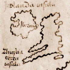
will bring up a detail of part of the British coast anomaly.
[NickP: this is http://vinland-map.brandeis.edu/assets/images/lightbox/ink.jpg , part of http://vinland-map.brandeis.edu/explore/material/baynes-cope.php ]
Nick and Friends, if you have not yet visited David “B”s link, you are missing some of the best research and cross-indexing I have ever seen. As a former Records Clerk/Indexer, and later Records Management & Research Paralegal, I give David B Ten-Star rating on a Ten ********** WWW Facebook- whatever chart ! I confine myself to one exclamation mark!
bdid1dr
Since I can’t find any previous mention, by me, of ‘L Anse aux Meadows (Newfoundland) I’ll refer you to a couple of more recent discoveries of pre-Viking native Americans, as well as the Viking village.
What I found most interesting is a book written by the daughter of the anthropologist who first investigated and identified the remains of the Viking-built village. National Geographic has also presented several reviews and discussions, which also involve the so-called “Vinland Map”. Apparently L’anse aux Meadows historical site is now part of Canada’s national park system. Apparently the Vikings didn’t hang around for long — wood was the most valuable item they needed. Once all the woods had been used up in Newfoundland AND Labrador,, the Vikings moved on.
😉
Not exactly- the Norse explorers seem to have abandoned their Vinland expeditions due to awkward (read lethal) relationships with the local inhabitants. However, they were still taking advantage of the timber resources in Markland (probably part of modern Labrador) some 350 years after their initial voyage to the Canadian coast.
Oops! The book I refer to is : ‘The New Land With Green Meadows’ written by Anne Stine Ingstad’ published 2013.
Oh yes, Mr. Bradbury, I plan to obtain a copy of the book.
I’ll be following up reference to “Markland”/Labrador.
Thanx!
bdid1dr
Anne Stine Ingstad also refers to “Dorset Paleoeskimo” as having camped in the area some 200 years before Vikings.
Overnight, I misplaced a note/excerpt that UC Davis Cahill and Moller did some PIXE spectroscopy on the V-map which contradicted Boenicke’s (McCrone?) findings of titanium in the ink/dating of the map.
On this same discussion of 1995, there is reference to an “unknown substance the British Museum had found across the whole map…(in short, there were traces of ‘fallout’ from the nuclear tests done in the 1950’s.
There is further discussion of “VMTR 95” on Wikipedia: Royal Danish Academy of Fine Arts/Rene Larsen, Kirsten Seaver, Kenneth Towe, John Paul Floyd, and Yale’s Librarian Alice Prochaska, and ‘Chester D. Tripp Prof. of History Paul Freedman.
Interesting!
Another feature which appears on the “Vinland Map” is a feature of the smaller island offshore of Newfoundland/Labrador: the long ‘rabbit-ear’ portion of the island is called “coney islandt”.
That really caught my eye because my ‘fodduh’s (father’s) favorite hangout in New York State was “Coney Island — in the 1930’s-40’s.
Nick, I’m hoping I’m not boring you with my sometimes appearing ‘nonsensical’ (if not irrelevant) posts.
bdid — and still 1-dr-ing
I have just followed Philip Neal’s link to his home page (given above) and found to my dismay that we are very much in disagreement on non-Voynich matters. I’ve just returned from what was to be a three-year scientific study of the effect of open-cut coal mine on local air, water and soil in one of the (now formerly-) richest farming areas in the state.
To my horror, I discovered that the aquifers are already broken, and the fracking fluids are already in the water on which the whole region depends for its water – drinking and agricultural and everything else. Some of disturbance has also brought radioactive materials in. The local school, which five years ago had 100 children is now likely to close, so many farmers driven out by the effects of the new mines that it will soon fall below the obligatory number of fifteen.
I lived for that year on a farm, and as part of the camp established by the people who came from all over the country to voice their protest. Somehow the mine looked much uglier than our temporary housing.
On the bright side, I realise that Philip is another of the ‘last men standing’ when the radiocarbon estimate came out. (Will go and add a footnote to my post).
I should have added that the frackers have moved into the same area, which is totally dependent on bore water for the greater part of the year, and otherwise on the local river. The gas-drills have ruined the one, and the mine has taken the other. That’s the free-trade mentality in government – as India learned quite some time ago.
Diane: I just recently unscrambled the identification of the island of Newfoundland and the Canadian mainland Labrador.
The island (which very much resembles, in outline, a “Coney” (aka: rabbit) IS and WAS “Newfoundland”. At the very tip of the ‘rabbit’s ear, is the Viking settlement of L’ ans Aux Meadows”.
Not too long ago, University of California (Davis?/Berkeley?) identified the source of so much confusion in radio-carbon- dating elderly manuscripts and maps: fallout from early nuclear bomb tests in the US.
So, I’m hoping that the folks at Boenicke have already caught up with the University of California’s findings.
beady-eyed as ever (but now using a large magnifying glass,)
Diane, do you know that oil-well developers explored the Northwest Passage several decades ago? It was one of the last deals which President Bush (Jr.) negotiated with the Canadian government before he left office. Other brokered deals were for oil pipelines through some of our Native American reservations (Black Hills, being one, if I can still recall fairly accurately).
Nowadays, many of our Native American organizations rely on the income from the gambling casinos they’ve been able to develop on their lands.
bdid
– so I believe.
Suppose the map is a forgery. Why on earth would someone put so much effort in doing a fake map of Vinland at that time? It was three years before viking remains were found in New Foundland. Correct me if I’m wrong, but at that time there were no evidence that Vinland was a real place. It was known from the Viking sagas which many believed were made up stories at that time. It would have been very much effort and time spent on a map that noone probably would believe in.
Another question arises. Why on earth would Columbous sail right out in the ocean with three ships, if he had no idea of what he would find? And why and how could the knowledge of the new continent found by the vikings be forgotten? For about 500 years Vikings lived at Greenland and never lost contact with Europe. The last Vikings left Greenland only a few decades before Columbus first voyage. Vikings traveled everywhere in Europe, and even ruled Sicily for a while a few generations before Coloumbus was born in northern Italy. It would be more unlikely that Coloumbus and other educated europeans never heard of Vinland.
Some say that vikings only spread their knowledge by oral communication. That’s not correct. Vikings had the rune alphabet and produced large numbers of rune stones. Would they only write on stones??? Probably not. But they didn’t use paper, that’s why nothing is preserved except rune stones. A couple of hundred years later Snorre Sturlasson wrote down the Viking sagas on paper. Since the Vikings were the most skilled boat builders and sea farers at that time, it would be very very strange if they didn’t use some kind of maps.
What I’m trying to say is that a Vinland map is not very unlikely. I’m not saying it’s real, but I doubt that any map have been examined so thoroughly as the Vinland map. One big reason is of course the lack of provenance but it’s important to keep in mind that many people would be upset if it was real. Especially if you in some way devoted your life to the history of Christoper Coulumbus.
Talking about maps…..
I’ve tried to respond to a question on Diane’s blog, related to a map by Opicinius de Canistris.
I hope this OT answer can be excused here, because this is such an unusual MS that it should be of general interest.
The MS may be found completely digitised here:
http://digi.ub.uni-heidelberg.de/diglit/bav_pal_lat_1993/
The only MS I know that literally consists of a pile of hides.
Rene
Can you tell me your difficulty in leaving a comment on my blog? Perhaps I can help. Obviously, the problem isn’t that you can’t read the posts, so is it a wordpress problem?
Rene,
There are two manuscripts of his work – the second just a set of bound sheets, as you say. I couldn’t recall which MS that diagram was from, but sorted it out in a day or so.
Hope others are as interested in that sheet. Thanks for sharing the reference.
Just in case anyone is still interested, I’ve finally got around to releasing my full-length study of the Vinland Map. It is currently available for pre-order as a Kindle ebook, and will be available as of 30 August 2018, by which time a paperback version (of around 500 pages) should also be up and running.
The title is: “A Sorry Saga: Theft, Forgery, Scholarship… and the Vinland Map.” Once the book is in distribution at the end of the month, any opinions or reviews (positive or critical) would be most welcome.
I hope it’s OK to include these links to the Amazon.com and Amazon.co.uk product pages (if not, please edit them out!):
https://www.amazon.com/dp/B07G8XQSYV
https://www.amazon.co.uk/dp/B07G8XQSYV
John Paul Floyd
John Paul Floyd: thanks very much for letting me know, I’ll order a copy straight away. 🙂
May I ask: how long have you been working on it, and in what major ways does it differ from Kirsten Seaver’s book?
Many thanks indeed, Nick. (I’m relieved – that’s at least one guaranteed sale! If it ever reaches five, I may consider early retirement).
To answer your question: I worked on the book for a couple of years (2013-15), then got kind of bored with the whole subject and left it to languish on my hard drive. Lately I dug it out, and figured I’d put so much work into the thing I should really put it out there in some form or another.
There is much careful scholarship in Kirsten Seaver’s 2004 book “Maps, Myths and Men,” but when it comes to identifying the suspect I feel she is like a detective who is determined to secure a conviction at all costs. To my mind, her case against Father Josef Fischer really doesn’t stand up, particularly in the light of of my discovery that the documents associated with the map definitely came from Zaragoza Cathedral Library.
The first few chapters of my own study are devoted to the story of the Zaragoza thefts of the 1950s, which saw stolen books and manuscripts end up in all sorts of respectable institutions, like Yale University and the British Museum. In my view, the looting of the library is absolutely central to the story of the Vinland Map. Kirsten Seaver only mentions Zaragoza in passing, on four or five pages of her 480-page book. So there is a major difference of perspective between us on that issue.
The other key difference, perhaps, is that I take a more dispassionate approach towards the subject in general (although, like Kirsten Seaver, I consider the map to be a forgery). I am not a partisan expert, but an amateur outsider. That perspective has left me free to subject both sides of the argument to some uncomfortable probing. For example, I devote a chapter to demolishing some very strange cartographical arguments of the late Professor E.G.R. Taylor, one of the earliest critics of the map’s authenticity.
My book culminates with a chapter setting out visual evidence that the person who created the Vinland Map made use of an 18th-century engraving by Vincenzo Formaleoni. This possibility does not seem to have occurred to Kirsten Seaver (or, in fairness, to any other expert over the past 50 years). I honestly feel that most people who read the chapter with an open mind will conclude this simple, obvious argument is a very strong one, and will be puzzled as to how it could have escaped everyone’s attention for so long. In short, nobody emerges entirely unscathed from the whole business.
JP: the Zaragoza thefts are something I’ve heard mentioned many times (Seaver indeed mentions it in the context of Witten’s denial that Ferrajoli had got it from Zaragoza at all, despite his 18 months in jail etc etc [p.97]), but have never seen a good account of, so for me that alone would make your book worth buying. 🙂
As to whether the Vinland Map is a forgery? Well, perhaps it is genuine, or even something in the awkward middle between the two – somehow “augmented”, let’s say. My years working with cipher mysteries have made me fairly attuned to the large grey areas between the polar macro-narratives that tend to dominate discourse, when real life tends to be a bit subtler than most people give it credit. 😉
I would definitely welcome any thoughts you might have after reading the book, Nick. The one thing I can promise is that “A Sorry Saga” does contain a lot of original research – it isn’t just a regurgitation of other published accounts. The level of detail may send readers to sleep in places, but I don’t think anyone will feel they’ve been short-changed. Thank you again for letting me mention it here, it’s much appreciated!
Having read “A Sorry Saga” I can confirm that it contains more previously uncollected information of relevance to the Vinland Map (particularly to Ferrajoli’s dealings, and the handling of the Zaragoza theft crisis by institutions such as the British Museum) than I would have thought possible! However, one of the best bits of the book is also one of the simplest: Mr Floyd’s long-hinted-at explanation of the caption on the BACK of the Map.
I don’t agree with everything he writes, particularly with regard to the various scientific studies of the Map, but even in that respect I can’t fault his comment that “The scientific controversy over the Vinland Map has been an extraordinary fiasco …”
The Vinland Map: An Opinion
by
Ronald Ryan, DA., PhD.
The extant information about the Vinland Map would be consistent with the following brief narrative.
Zheng He arrived at what is now called Newfoundland Island in the summer of 1418. He found the island devoid of human life. Maybe after naming the place “The Island like a Chinese Garden” (the four characters on the Matteo Ricci map), he proceeded to Greenland. Whether he had a map and had some idea where he was going is a rather interesting question.
Having arrived in Greenland and finding the 5000 or so inhabitants verging on starvation, he gave them the option of coming back to Newfoundland, already known to the Greenland Norse as Vinland. The people and their priests – and likely, their sheep – arrived on this island late summer, 1418 and along with the Chinese began to establish a medieval Norse-Chinese civilization.
Zheng He departed and returned to China, arriving sometime in 1419, but leaving numerous people to share the building of a new society, crafts people, medical people, and so on.
Zheng he returned in 1435 and spent his last days in peace.
There are legends of documents in the Vatican Archives that indicate that tributes came to the Holy See from Vinland.
Up to that point, I have pretty well proven.
Ok. From this point on, I am speculating:
One of the priests, wanting to indicate to the pope where Vinland was, drew a rough map and included it with the Bishop’s Vinland tribute and his report.
The missing 65 or so pages refers to the civilization, consisting of about 300 000 people, who were murdered by the British and French around 1700. It was not a fact that the British and French wanted to be known and discussed.
Someone took the map from the Vatican Archives, at least long enough to copy. Maybe, that someone wanted to embarrass the British and French. Before it could gain traction, somebody cut out the offensive pages.
The original may still be in the Vatican Archives.
Ronald Ryan, DA., PhD
[email protected]
St. John’s, NL Canada
1-902-476-5955
New York Times
“Yale Says Its Vinland Map, Once Called a Medieval Treasure, Is Fake.
https://www.nytimes.com/2021/09/30/us/yale-vinland-map-fake.html
Clemmo’s gotta be joking surely, what about the fifteenth century double spectro carbon dating huh. Turns out to be ligit, it can only mean he’s testing the water for hostile reaction, if no waves Voyicheros can prepare for the bombora and wipeout .to follow.